Rembertów geodata
Rembertów (Mazovia) is a populated place; located in Poland in Europe/Warsaw (GMT+2) time zone. With population of 21,893 people, there are 224 cities with bigger population in this country. Compared to other cities in Poland, 71.8% of cities are located further ↓South; 75.4% of cities are located further ←West and 84.1% of cities have higher elevation than Rembertów. Note1


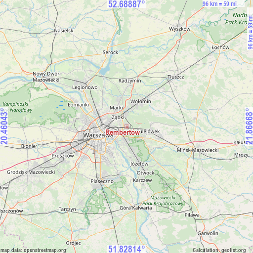
Rembertów GPS coordinates[2]
52° 15' 38.124" North, 21° 9' 48.78" East
| Map corner | latitude | longitude |
|---|---|---|
| Upper-left | 52.68887°, | 20.46043° |
| Center: | 52.26059°, | 21.16355° |
| Lower-right: | 51.82814°, | 21.86668° |
| Map W x H: | 95.7×95.7 km | = 59.5×59.5mi |
| max Lat: | 54.83135° ⇑28.2% North |
| Rembertów: | 52.26059° |
| min Lat: | ⇓71.8% South 49.21328° |
| min Long | Rembertów | max Long |
| 14.20249° | 21.16355° | 24.03723° |
| W 75.4%⇐ | ⇒24.6% E |
Elevation
Elevation of Rembertów is 91 m = 299 ft, and this is 100.4 m = 329 ft below average elevation for this country.
| Max E: |
974 m = 3196 ft | 84.1% |
| Avg. | 191.4 m = 628 ft | |
| Rembertów | 91 m = 299 ft | |
Min E: |
-3 m = -10 ft | 15.9% |
See also: Poland elevation on elevation.city.
Geographical zone
Rembertów is located in North temperate zone (between Tropic of Cancer and the Arctic Circle). Distance of this North polar circle is 1590.3 km =988.2 mi to North.| Distance of | km | miles | from Rembertów |
|---|---|---|---|
| North Pole | 4196.2 | 2607.4 | to North |
| Arctic Circle | 1590.3 | 988.2 | to North |
| Tropic Cancer | 3204.9 | 1991.4 | to South |
| Equator | 5810.8 | 3610.7 | to South |


Nearby cities:
15 places around Rembertów: (largest is in red/bold)
• Kobyłka
9 km =5.6 mi,  14°
14°
• Marki
7.8 km =4.8 mi,  329°
329°
• Mokotów
11.5 km =7.1 mi,  229°
229°
• Praga Południe
5.6 km =3.5 mi,  251°
251°
• Praga Północ
8.8 km =5.5 mi,  265°
265°
• Sulejówek
7.2 km =4.5 mi,  97°
97°
• Targówek
8.6 km =5.3 mi,  293°
293°
• Warsaw
10.9 km =6.8 mi, 251°
• Wawer
7.2 km =4.5 mi,  172°
172°
• Wesoła
4.2 km =2.6 mi, 99°
• Wilanów
12 km =7.5 mi,  205°
205°
• Wołomin
10.3 km =6.4 mi,  31°
31°
• Zielonka
4.8 km =3 mi,  357°
357°
• Ząbki
5.3 km =3.3 mi,  312°
312°
• Śródmieście
10.6 km =6.6 mi, 250°
Sources, notices
• [Note1] Compared only with cities in Poland existing in our database
• [Src1] Map data: © OpenStreetMap contributors (CC-BY-SA)
• [Src2] Other city data from geonames.org with taken over terms of usage.
• [Src3] Geographical zone / Annual Mean Temperature by Robert A. Rohde @ Wikipedia
