Borzęcin geodata
Borzęcin (Lesser Poland) is a seat of a third-order administrative division; located in Poland in Europe/Warsaw (GMT+2) time zone. With population of 3,865 people, there are 843 cities with bigger population in this country. Compared to other cities in Poland, 79.4% of cities are located further ↑North; 67.8% of cities are located further ←West and 56.8% of cities have lower elevation than Borzęcin. Note1


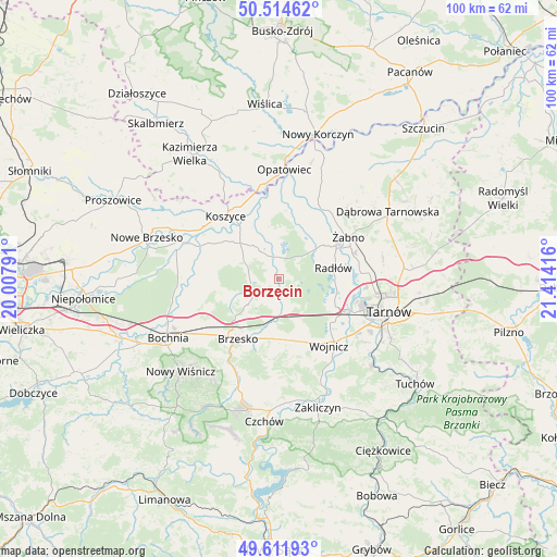
Borzęcin GPS coordinates[2]
50° 3' 55.44" North, 20° 42' 39.708" East
| Map corner | latitude | longitude |
|---|---|---|
| Upper-left | 50.51462°, | 20.00791° |
| Center: | 50.0654°, | 20.71103° |
| Lower-right: | 49.61193°, | 21.41416° |
| Map W x H: | 100.4×100.4 km | = 62.4×62.4mi |
| max Lat: | 54.83135° ⇑79.4% North |
| Borzęcin: | 50.0654° |
| min Lat: | ⇓20.6% South 49.21328° |
| min Long | Borzęcin | max Long |
| 14.20249° | 20.71103° | 24.03723° |
| W 67.8%⇐ | ⇒32.2% E |
Elevation
Elevation of Borzęcin is 190 m = 623 ft, and this is 1.4 m = 5 ft below average elevation for this country.
| Max E: |
974 m = 3196 ft | 43.2% |
| Avg. | 191.4 m = 628 ft | |
| Borzęcin | 190 m = 623 ft | |
Min E: |
-3 m = -10 ft | 56.8% |
See also: Poland elevation on elevation.city.
Geographical zone
Borzęcin is located in North temperate zone (between Tropic of Cancer and the Arctic Circle). Distance of this North polar circle is 1834.4 km =1139.8 mi to North.| Distance of | km | miles | from Borzęcin |
|---|---|---|---|
| North Pole | 4440.3 | 2759.1 | to North |
| Arctic Circle | 1834.4 | 1139.8 | to North |
| Tropic Cancer | 2960.8 | 1839.8 | to South |
| Equator | 5566.8 | 3459 | to South |


Nearby cities:
15 places around Borzęcin: (largest is in red/bold)
• Dębno
11 km =6.8 mi,  176°
176°
• Jadowniki Mokre
11.2 km =7 mi,  6°
6°
• Maszkienice
8.7 km =5.4 mi,  191°
191°
• Przyborów
5.2 km =3.2 mi,  221°
221°
• Radłów
10.1 km =6.3 mi,  78°
78°
• Rudy-Rysie
5.2 km =3.2 mi,  264°
264°
• Sterkowiec
8.1 km =5 mi,  195°
195°
• Strzelce Wielkie
9.8 km =6.1 mi,  288°
288°
• Szczepanów
7.8 km =4.8 mi,  211°
211°
• Szczurowa
8 km =5 mi,  318°
318°
• Wierzchosławice
11.3 km =7 mi,  113°
113°
• Wokowice
6.6 km =4.1 mi, 186°
• Wola Dębińska
9.4 km =5.8 mi, 190°
• Zabawa
10 km =6.2 mi,  52°
52°
• Zaborów
9.2 km =5.7 mi,  350°
350°
Sources, notices
• [Note1] Compared only with cities in Poland existing in our database
• [Src1] Map data: © OpenStreetMap contributors (CC-BY-SA)
• [Src2] Other city data from geonames.org with taken over terms of usage.
• [Src3] Geographical zone / Annual Mean Temperature by Robert A. Rohde @ Wikipedia
