Baranów Sandomierski geodata
Baranów Sandomierski (Subcarpathian) is a seat of a third-order administrative division; located in Poland in Europe/Warsaw (GMT+2) time zone. With population of 1,426 people, there are 1931 cities with bigger population in this country. Compared to other cities in Poland, 67.4% of cities are located further ↑North; 79.5% of cities are located further ←West and 58.4% of cities have higher elevation than Baranów Sandomierski. Note1
Administrative division(s):
- Level 1: Subcarpathian
- Level 2: Powiat tarnobrzeski
- Level 3: Baranów Sandomierski


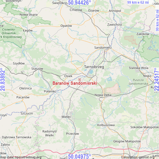
Baranów Sandomierski GPS coordinates[2]
50° 29' 56.832" North, 21° 32' 31.344" East
| Map corner | latitude | longitude |
|---|---|---|
| Upper-left | 50.94426°, | 20.83892° |
| Center: | 50.49912°, | 21.54204° |
| Lower-right: | 50.04975°, | 22.24517° |
| Map W x H: | 99.5×99.5 km | = 61.8×61.8mi |
| max Lat: | 54.83135° ⇑67.4% North |
| Baranów Sandomierski: | 50.49912° |
| min Lat: | ⇓32.6% South 49.21328° |
| min Long | Baranów Sandom | max Long |
| 14.20249° | 21.54204° | 24.03723° |
| W 79.5%⇐ | ⇒20.5% E |
Elevation
Elevation of Baranów Sandomierski is 150 m = 492 ft, and this is 41.4 m = 136 ft below average elevation for this country.
| Max E: |
974 m = 3196 ft | 58.4% |
| Avg. | 191.4 m = 628 ft | |
| Baranów Sandomierski | 150 m = 492 ft | |
Min E: |
-3 m = -10 ft | 41.6% |
See also: Poland elevation on elevation.city.
Geographical zone
Baranów Sandomierski is located in North temperate zone (between Tropic of Cancer and the Arctic Circle). Distance of this North polar circle is 1786.2 km =1109.9 mi to North.| Distance of | km | miles | from Baranów Sandomierski |
|---|---|---|---|
| North Pole | 4392.1 | 2729.1 | to North |
| Arctic Circle | 1786.2 | 1109.9 | to North |
| Tropic Cancer | 3009.1 | 1869.8 | to South |
| Equator | 5615 | 3489 | to South |


Nearby cities:
15 places around Baranów Sandomierski: (largest is in red/bold)
• Borowa
18.5 km =11.5 mi,  226°
226°
• Gawłuszowice
14.7 km =9.1 mi, 229°
• Klimontów
18.5 km =11.5 mi,  340°
340°
• Koprzywnica
10.9 km =6.8 mi,  15°
15°
• Majdan Królewski
19.7 km =12.2 mi,  132°
132°
• Nowa Dęba
16.7 km =10.4 mi,  117°
117°
• Osiek
7.4 km =4.6 mi,  288°
288°
• Ostrowy Baranowskie
19.7 km =12.2 mi,  155°
155°
• Padew Narodowa
7.3 km =4.5 mi,  203°
203°
• Połaniec
19.9 km =12.4 mi,  248°
248°
• Samborzec
18 km =11.2 mi, 24°
• Tarnobrzeg
12.7 km =7.9 mi,  49°
49°
• Tuszów Narodowy
15.2 km =9.4 mi, 202°
• Łoniów
7.3 km =4.5 mi,  351°
351°
• Świniary Stare
4.3 km =2.7 mi, 349°
Sources, notices
• [Note1] Compared only with cities in Poland existing in our database
• [Src1] Map data: © OpenStreetMap contributors (CC-BY-SA)
• [Src2] Other city data from geonames.org with taken over terms of usage.
• [Src3] Geographical zone / Annual Mean Temperature by Robert A. Rohde @ Wikipedia
