Świniary Stare geodata
Świniary Stare (Świętokrzyskie) is a populated place; located in Poland in Europe/Warsaw (GMT+2) time zone. With population of 600 people, there are 3270 cities with bigger population in this country. Compared to other cities in Poland, 66.6% of cities are located further ↑North; 79.4% of cities are located further ←West and 52.1% of cities have higher elevation than Świniary Stare. Note1


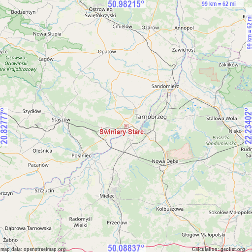
Świniary Stare GPS coordinates[2]
50° 32' 14.568" North, 21° 31' 51.204" East
| Map corner | latitude | longitude |
|---|---|---|
| Upper-left | 50.98215°, | 20.82777° |
| Center: | 50.53738°, | 21.53089° |
| Lower-right: | 50.08837°, | 22.23402° |
| Map W x H: | 99.4×99.4 km | = 61.8×61.8mi |
| max Lat: | 54.83135° ⇑66.6% North |
| Świniary Stare: | 50.53738° |
| min Lat: | ⇓33.4% South 49.21328° |
| min Long | Świniary Stare | max Long |
| 14.20249° | 21.53089° | 24.03723° |
| W 79.4%⇐ | ⇒20.6% E |
Elevation
Elevation of Świniary Stare is 166 m = 545 ft, and this is 25.4 m = 83 ft below average elevation for this country.
| Max E: |
974 m = 3196 ft | 52.1% |
| Avg. | 191.4 m = 628 ft | |
| Świniary Stare | 166 m = 545 ft | |
Min E: |
-3 m = -10 ft | 47.9% |
See also: Poland elevation on elevation.city.
Geographical zone
Świniary Stare is located in North temperate zone (between Tropic of Cancer and the Arctic Circle). Distance of this North polar circle is 1781.9 km =1107.2 mi to North.| Distance of | km | miles | from Świniary Stare |
|---|---|---|---|
| North Pole | 4387.8 | 2726.5 | to North |
| Arctic Circle | 1781.9 | 1107.2 | to North |
| Tropic Cancer | 3013.3 | 1872.4 | to South |
| Equator | 5619.2 | 3491.6 | to South |


Nearby cities:
15 places around Świniary Stare: (largest is in red/bold)
• Baranów Sandomierski
4.3 km =2.7 mi,  169°
169°
• Borowa
21.1 km =13.1 mi,  216°
216°
• Gawłuszowice
17.3 km =10.7 mi, 217°
• Klimontów
14.2 km =8.8 mi,  338°
338°
• Koprzywnica
7.3 km =4.5 mi,  30°
30°
• Nowa Dęba
19.6 km =12.2 mi,  127°
127°
• Obrazów
19.2 km =11.9 mi, 26°
• Osiek
6.6 km =4.1 mi,  252°
252°
• Padew Narodowa
11.1 km =6.9 mi,  191°
191°
• Samborzec
14.7 km =9.1 mi, 34°
• Tarnobrzeg
11.2 km =7 mi,  69°
69°
• Tuszów Narodowy
19 km =11.8 mi,  195°
195°
• Wiśniowa
20.7 km =12.9 mi,  287°
287°
• Złota
17.5 km =10.9 mi,  37°
37°
• Łoniów
3 km =1.9 mi,  353°
353°
Sources, notices
• [Note1] Compared only with cities in Poland existing in our database
• [Src1] Map data: © OpenStreetMap contributors (CC-BY-SA)
• [Src2] Other city data from geonames.org with taken over terms of usage.
• [Src3] Geographical zone / Annual Mean Temperature by Robert A. Rohde @ Wikipedia
