Połaniec geodata
Połaniec (Świętokrzyskie) is a seat of a third-order administrative division; located in Poland in Europe/Warsaw (GMT+2) time zone. With population of 8,158 people, there are 503 cities with bigger population in this country. Compared to other cities in Poland, 68.7% of cities are located further ↑North; 76.8% of cities are located further ←West and 52.9% of cities have higher elevation than Połaniec. Note1


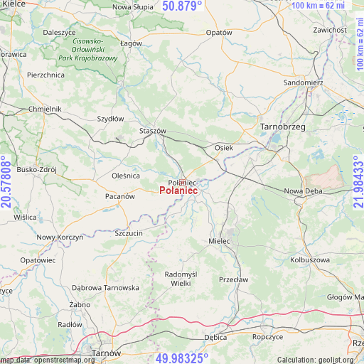
Połaniec GPS coordinates[2]
50° 25' 59.664" North, 21° 16' 52.32" East
| Map corner | latitude | longitude |
|---|---|---|
| Upper-left | 50.879°, | 20.57808° |
| Center: | 50.43324°, | 21.2812° |
| Lower-right: | 49.98325°, | 21.98433° |
| Map W x H: | 99.6×99.6 km | = 61.9×61.9mi |
| max Lat: | 54.83135° ⇑68.7% North |
| Połaniec: | 50.43324° |
| min Lat: | ⇓31.3% South 49.21328° |
| min Long | Połaniec | max Long |
| 14.20249° | 21.2812° | 24.03723° |
| W 76.8%⇐ | ⇒23.2% E |
Elevation
Elevation of Połaniec is 164 m = 538 ft, and this is 27.4 m = 90 ft below average elevation for this country.
| Max E: |
974 m = 3196 ft | 52.9% |
| Avg. | 191.4 m = 628 ft | |
| Połaniec | 164 m = 538 ft | |
Min E: |
-3 m = -10 ft | 47.1% |
See also: Poland elevation on elevation.city.
Geographical zone
Połaniec is located in North temperate zone (between Tropic of Cancer and the Arctic Circle). Distance of this North polar circle is 1793.5 km =1114.4 mi to North.| Distance of | km | miles | from Połaniec |
|---|---|---|---|
| North Pole | 4399.4 | 2733.7 | to North |
| Arctic Circle | 1793.5 | 1114.4 | to North |
| Tropic Cancer | 3001.7 | 1865.2 | to South |
| Equator | 5607.7 | 3484.5 | to South |


Nearby cities:
15 places around Połaniec: (largest is in red/bold)
• Borowa
7.3 km =4.5 mi,  136°
136°
• Czermin
11.1 km =6.9 mi,  160°
160°
• Gawłuszowice
7.5 km =4.7 mi,  106°
106°
• Oleśnica
15.5 km =9.6 mi,  278°
278°
• Osiek
14.9 km =9.3 mi,  49°
49°
• Pacanów
17.4 km =10.8 mi,  257°
257°
• Padew Narodowa
15.6 km =9.7 mi,  87°
87°
• Rytwiany
11.9 km =7.4 mi,  333°
333°
• Staszów
16.6 km =10.3 mi, 330°
• Słupia
18 km =11.2 mi,  251°
251°
• Słupiec
13.3 km =8.3 mi,  207°
207°
• Trzciana
14.5 km =9 mi, 164°
• Tuszów Narodowy
14.3 km =8.9 mi,  118°
118°
• Wiśniowa
17.9 km =11.1 mi,  353°
353°
• Łubnice
9.6 km =6 mi, 255°
Sources, notices
• [Note1] Compared only with cities in Poland existing in our database
• [Src1] Map data: © OpenStreetMap contributors (CC-BY-SA)
• [Src2] Other city data from geonames.org with taken over terms of usage.
• [Src3] Geographical zone / Annual Mean Temperature by Robert A. Rohde @ Wikipedia
