Gawłuszowice geodata
Gawłuszowice (Subcarpathian) is a populated place; located in Poland in Europe/Warsaw (GMT+2) time zone. With population of 700 people, there are 3061 cities with bigger population in this country. Compared to other cities in Poland, 69.2% of cities are located further ↑North; 77.8% of cities are located further ←West and 56% of cities have higher elevation than Gawłuszowice. Note1


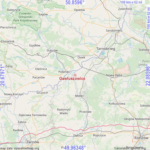
Gawłuszowice GPS coordinates[2]
50° 24' 49.176" North, 21° 22' 58.188" East
| Map corner | latitude | longitude |
|---|---|---|
| Upper-left | 50.8596°, | 20.67971° |
| Center: | 50.41366°, | 21.38283° |
| Lower-right: | 49.96348°, | 22.08596° |
| Map W x H: | 99.6×99.6 km | = 61.9×61.9mi |
| max Lat: | 54.83135° ⇑69.2% North |
| Gawłuszowice: | 50.41366° |
| min Lat: | ⇓30.8% South 49.21328° |
| min Long | Gawłuszowice | max Long |
| 14.20249° | 21.38283° | 24.03723° |
| W 77.8%⇐ | ⇒22.2% E |
Elevation
Elevation of Gawłuszowice is 156 m = 512 ft, and this is 35.4 m = 116 ft below average elevation for this country.
| Max E: |
974 m = 3196 ft | 56% |
| Avg. | 191.4 m = 628 ft | |
| Gawłuszowice | 156 m = 512 ft | |
Min E: |
-3 m = -10 ft | 44% |
See also: Poland elevation on elevation.city.
Geographical zone
Gawłuszowice is located in North temperate zone (between Tropic of Cancer and the Arctic Circle). Distance of this North polar circle is 1795.7 km =1115.8 mi to North.| Distance of | km | miles | from Gawłuszowice |
|---|---|---|---|
| North Pole | 4401.6 | 2735 | to North |
| Arctic Circle | 1795.7 | 1115.8 | to North |
| Tropic Cancer | 2999.6 | 1863.9 | to South |
| Equator | 5605.5 | 3483.1 | to South |


Nearby cities:
15 places around Gawłuszowice: (largest is in red/bold)
• Baranów Sandomierski
14.7 km =9.1 mi,  49°
49°
• Borowa
3.8 km =2.4 mi,  215°
215°
• Czermin
9 km =5.6 mi,  202°
202°
• Mielec
14.4 km =8.9 mi,  168°
168°
• Osiek
12.5 km =7.8 mi,  19°
19°
• Padew Narodowa
8.8 km =5.5 mi,  71°
71°
• Połaniec
7.5 km =4.7 mi,  286°
286°
• Rytwiany
17.9 km =11.1 mi,  315°
315°
• Słupiec
16.5 km =10.3 mi,  234°
234°
• Trzciana
12.2 km =7.6 mi, 195°
• Tuszów Narodowy
7 km =4.3 mi,  130°
130°
• Wadowice Górne
17.7 km =11 mi, 198°
• Łoniów
19.6 km =12.2 mi,  31°
31°
• Łubnice
16.5 km =10.3 mi,  269°
269°
• Świniary Stare
17.3 km =10.7 mi,  37°
37°
Sources, notices
• [Note1] Compared only with cities in Poland existing in our database
• [Src1] Map data: © OpenStreetMap contributors (CC-BY-SA)
• [Src2] Other city data from geonames.org with taken over terms of usage.
• [Src3] Geographical zone / Annual Mean Temperature by Robert A. Rohde @ Wikipedia
