Pniewy geodata
Pniewy (Mazovia) is a seat of a third-order administrative division; located in Poland in Europe/Warsaw (GMT+2) time zone. In our database, there are 3649 cities with bigger population. Compared to other cities in Poland, 64% of cities are located further ↓South; 68.3% of cities are located further ←West and 50.8% of cities have lower elevation than Pniewy. Note1


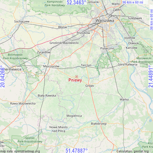
Pniewy GPS coordinates[2]
51° 54' 52.848" North, 20° 44' 44.808" East
| Map corner | latitude | longitude |
|---|---|---|
| Upper-left | 52.3463°, | 20.04266° |
| Center: | 51.91468°, | 20.74578° |
| Lower-right: | 51.47887°, | 21.44891° |
| Map W x H: | 96.4×96.4 km | = 59.9×59.9mi |
| max Lat: | 54.83135° ⇑36% North |
| Pniewy: | 51.91468° |
| min Lat: | ⇓64% South 49.21328° |
| min Long | Pniewy | max Long |
| 14.20249° | 20.74578° | 24.03723° |
| W 68.3%⇐ | ⇒31.7% E |
Elevation
Elevation of Pniewy is 174 m = 571 ft, and this is 17.4 m = 57 ft below average elevation for this country.
| Max E: |
974 m = 3196 ft | 49.2% |
| Avg. | 191.4 m = 628 ft | |
| Pniewy | 174 m = 571 ft | |
Min E: |
-3 m = -10 ft | 50.8% |
See also: Poland elevation on elevation.city.
Geographical zone
Pniewy is located in North temperate zone (between Tropic of Cancer and the Arctic Circle). Distance of this North polar circle is 1628.8 km =1012.1 mi to North.| Distance of | km | miles | from Pniewy |
|---|---|---|---|
| North Pole | 4234.7 | 2631.3 | to North |
| Arctic Circle | 1628.8 | 1012.1 | to North |
| Tropic Cancer | 3166.5 | 1967.6 | to South |
| Equator | 5772.4 | 3586.8 | to South |


Nearby cities:
15 places around Pniewy: (largest is in red/bold)
• Belsk Duży
10.8 km =6.7 mi,  156°
156°
• Błędów
15.6 km =9.7 mi,  192°
192°
• Goszczyn
21.6 km =13.4 mi, 160°
• Gołków
20.9 km =13 mi,  47°
47°
• Grójec
10.2 km =6.3 mi,  124°
124°
• Jasieniec
17 km =10.6 mi,  127°
127°
• Jazgarzew
22.1 km =13.7 mi, 51°
• Książenice
18.4 km =11.4 mi,  349°
349°
• Mszczonów
16.8 km =10.4 mi,  293°
293°
• Nadarzyn
20.4 km =12.7 mi,  11°
11°
• Owczarnia
22 km =13.7 mi, 352°
• Prażmów
14.6 km =9.1 mi,  78°
78°
• Radziejowice
17.1 km =10.6 mi,  307°
307°
• Tarczyn
9.6 km =6 mi,  38°
38°
• Żabia Wola
13.5 km =8.4 mi,  343°
343°
Sources, notices
• [Note1] Compared only with cities in Poland existing in our database
• [Src1] Map data: © OpenStreetMap contributors (CC-BY-SA)
• [Src2] Other city data from geonames.org with taken over terms of usage.
• [Src3] Geographical zone / Annual Mean Temperature by Robert A. Rohde @ Wikipedia
