Grójec geodata
Grójec (Mazovia) is a seat of a third-order administrative division; located in Poland in Europe/Warsaw (GMT+2) time zone. With population of 14,880 people, there are 336 cities with bigger population in this country. Compared to other cities in Poland, 63% of cities are located further ↓South; 70.4% of cities are located further ←West and 57.1% of cities have higher elevation than Grójec. Note1


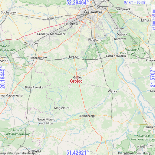
Grójec GPS coordinates[2]
51° 51' 45.072" North, 20° 52' 3.252" East
| Map corner | latitude | longitude |
|---|---|---|
| Upper-left | 52.29464°, | 20.16445° |
| Center: | 51.86252°, | 20.86757° |
| Lower-right: | 51.42621°, | 21.5707° |
| Map W x H: | 96.6×96.6 km | = 60×60mi |
| max Lat: | 54.83135° ⇑37% North |
| Grójec: | 51.86252° |
| min Lat: | ⇓63% South 49.21328° |
| min Long | Grójec | max Long |
| 14.20249° | 20.86757° | 24.03723° |
| W 70.4%⇐ | ⇒29.6% E |
Elevation
Elevation of Grójec is 153 m = 502 ft, and this is 38.4 m = 126 ft below average elevation for this country.
| Max E: |
974 m = 3196 ft | 57.1% |
| Avg. | 191.4 m = 628 ft | |
| Grójec | 153 m = 502 ft | |
Min E: |
-3 m = -10 ft | 42.9% |
See also: Poland elevation on elevation.city.
Geographical zone
Grójec is located in North temperate zone (between Tropic of Cancer and the Arctic Circle). Distance of this North polar circle is 1634.6 km =1015.7 mi to North.| Distance of | km | miles | from Grójec |
|---|---|---|---|
| North Pole | 4240.5 | 2634.9 | to North |
| Arctic Circle | 1634.6 | 1015.7 | to North |
| Tropic Cancer | 3160.7 | 1964 | to South |
| Equator | 5766.6 | 3583.2 | to South |


Nearby cities:
15 places around Grójec: (largest is in red/bold)
• Belsk Duży
5.8 km =3.6 mi,  224°
224°
• Błędów
15 km =9.3 mi,  231°
231°
• Chynów
15.4 km =9.6 mi,  72°
72°
• Goszczyn
14.6 km =9.1 mi,  184°
184°
• Gołków
21.1 km =13.1 mi,  19°
19°
• Jasieniec
6.8 km =4.2 mi,  132°
132°
• Jazgarzew
21.6 km =13.4 mi, 24°
• Mogielnica
21.2 km =13.2 mi,  208°
208°
• Pniewy
10.2 km =6.3 mi,  304°
304°
• Prażmów
10.5 km =6.5 mi,  34°
34°
• Promna
21.2 km =13.2 mi,  162°
162°
• Przybyszew
22.2 km =13.8 mi, 182°
• Sułkowice
16.6 km =10.3 mi, 66°
• Tarczyn
13.5 km =8.4 mi,  350°
350°
• Zalesie Górne
21.7 km =13.5 mi, 32°
Sources, notices
• [Note1] Compared only with cities in Poland existing in our database
• [Src1] Map data: © OpenStreetMap contributors (CC-BY-SA)
• [Src2] Other city data from geonames.org with taken over terms of usage.
• [Src3] Geographical zone / Annual Mean Temperature by Robert A. Rohde @ Wikipedia
