Bolesław geodata
Bolesław (Lesser Poland) is a populated place; located in Poland in Europe/Warsaw (GMT+2) time zone. With population of 539 people, there are 3438 cities with bigger population in this country. Compared to other cities in Poland, 72.7% of cities are located further ↑North; 70.8% of cities are located further ←West and 51.3% of cities have higher elevation than Bolesław. Note1


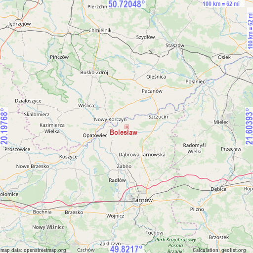
Bolesław GPS coordinates[2]
50° 16' 23.556" North, 20° 54' 2.88" East
| Map corner | latitude | longitude |
|---|---|---|
| Upper-left | 50.72048°, | 20.19768° |
| Center: | 50.27321°, | 20.9008° |
| Lower-right: | 49.8217°, | 21.60393° |
| Map W x H: | 99.9×99.9 km | = 62.1×62.1mi |
| max Lat: | 54.83135° ⇑72.7% North |
| Bolesław: | 50.27321° |
| min Lat: | ⇓27.3% South 49.21328° |
| min Long | Bolesław | max Long |
| 14.20249° | 20.9008° | 24.03723° |
| W 70.8%⇐ | ⇒29.2% E |
Elevation
Elevation of Bolesław is 169 m = 554 ft, and this is 22.4 m = 73 ft below average elevation for this country.
| Max E: |
974 m = 3196 ft | 51.3% |
| Avg. | 191.4 m = 628 ft | |
| Bolesław | 169 m = 554 ft | |
Min E: |
-3 m = -10 ft | 48.7% |
See also: Poland elevation on elevation.city.
Geographical zone
Bolesław is located in North temperate zone (between Tropic of Cancer and the Arctic Circle). Distance of this North polar circle is 1811.3 km =1125.5 mi to North.| Distance of | km | miles | from Bolesław |
|---|---|---|---|
| North Pole | 4417.2 | 2744.7 | to North |
| Arctic Circle | 1811.3 | 1125.5 | to North |
| Tropic Cancer | 2983.9 | 1854.1 | to South |
| Equator | 5589.9 | 3473.4 | to South |


Nearby cities:
15 places around Bolesław: (largest is in red/bold)
• Dąbrowa Tarnowska
12.5 km =7.8 mi,  150°
150°
• Gorzyce
10.3 km =6.4 mi,  196°
196°
• Gruszów Wielki
13 km =8.1 mi,  134°
134°
• Gręboszów
9.4 km =5.8 mi,  250°
250°
• Mędrzechów
3.5 km =2.2 mi,  73°
73°
• Nieciecza
13.9 km =8.6 mi, 195°
• Nowy Korczyn
7.3 km =4.5 mi,  295°
295°
• Odporyszów
13.5 km =8.4 mi,  176°
176°
• Olesno
8.2 km =5.1 mi,  167°
167°
• Opatowiec
13 km =8.1 mi,  255°
255°
• Smęgorzów
8.9 km =5.5 mi,  124°
124°
• Solec-Zdrój
10.3 km =6.4 mi,  355°
355°
• Swarzów
9.5 km =5.9 mi,  155°
155°
• Szczucin
13 km =8.1 mi, 71°
• Wietrzychowice
13.3 km =8.3 mi,  226°
226°
Sources, notices
• [Note1] Compared only with cities in Poland existing in our database
• [Src1] Map data: © OpenStreetMap contributors (CC-BY-SA)
• [Src2] Other city data from geonames.org with taken over terms of usage.
• [Src3] Geographical zone / Annual Mean Temperature by Robert A. Rohde @ Wikipedia
