Radgoszcz geodata
Radgoszcz (Lesser Poland) is a seat of a third-order administrative division; located in Poland in Europe/Warsaw (GMT+2) time zone. With population of 3,700 people, there are 871 cities with bigger population in this country. Compared to other cities in Poland, 74.3% of cities are located further ↑North; 74.6% of cities are located further ←West and 53.5% of cities have lower elevation than Radgoszcz. Note1


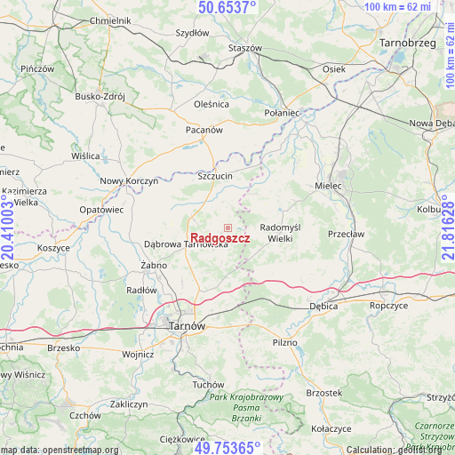
Radgoszcz GPS coordinates[2]
50° 12' 20.88" North, 21° 6' 47.34" East
| Map corner | latitude | longitude |
|---|---|---|
| Upper-left | 50.6537°, | 20.41003° |
| Center: | 50.2058°, | 21.11315° |
| Lower-right: | 49.75365°, | 21.81628° |
| Map W x H: | 100.1×100.1 km | = 62.2×62.2mi |
| max Lat: | 54.83135° ⇑74.3% North |
| Radgoszcz: | 50.2058° |
| min Lat: | ⇓25.7% South 49.21328° |
| min Long | Radgoszcz | max Long |
| 14.20249° | 21.11315° | 24.03723° |
| W 74.6%⇐ | ⇒25.4% E |
Elevation
Elevation of Radgoszcz is 181 m = 594 ft, and this is 10.4 m = 34 ft below average elevation for this country.
| Max E: |
974 m = 3196 ft | 46.5% |
| Avg. | 191.4 m = 628 ft | |
| Radgoszcz | 181 m = 594 ft | |
Min E: |
-3 m = -10 ft | 53.5% |
See also: Poland elevation on elevation.city.
Geographical zone
Radgoszcz is located in North temperate zone (between Tropic of Cancer and the Arctic Circle). Distance of this North polar circle is 1818.8 km =1130.1 mi to North.| Distance of | km | miles | from Radgoszcz |
|---|---|---|---|
| North Pole | 4424.7 | 2749.4 | to North |
| Arctic Circle | 1818.8 | 1130.1 | to North |
| Tropic Cancer | 2976.4 | 1849.4 | to South |
| Equator | 5582.4 | 3468.7 | to South |


Nearby cities:
15 places around Radgoszcz: (largest is in red/bold)
• Dąbrowa Tarnowska
9.7 km =6 mi,  248°
248°
• Gruszów Wielki
6 km =3.7 mi, 254°
• Lisia Góra
14.8 km =9.2 mi,  199°
199°
• Mędrzechów
14.5 km =9 mi,  305°
305°
• Odporyszów
15.5 km =9.6 mi, 247°
• Olesno
13.3 km =8.3 mi,  267°
267°
• Radomyśl Wielki
11.7 km =7.3 mi,  94°
94°
• Sieradza
15.3 km =9.5 mi,  238°
238°
• Smyków
6.9 km =4.3 mi,  171°
171°
• Smęgorzów
8.2 km =5.1 mi,  287°
287°
• Swarzów
11.3 km =7 mi,  263°
263°
• Szczucin
11.9 km =7.4 mi,  346°
346°
• Słupiec
14.7 km =9.1 mi,  22°
22°
• Wadowice Górne
14.9 km =9.3 mi,  64°
64°
• Łukowa
15.9 km =9.9 mi,  218°
218°
Sources, notices
• [Note1] Compared only with cities in Poland existing in our database
• [Src1] Map data: © OpenStreetMap contributors (CC-BY-SA)
• [Src2] Other city data from geonames.org with taken over terms of usage.
• [Src3] Geographical zone / Annual Mean Temperature by Robert A. Rohde @ Wikipedia
