Białobrzegi geodata
Białobrzegi (Mazovia) is a populated place; located in Poland in Europe/Warsaw (GMT+2) time zone. With population of 1,208 people, there are 2161 cities with bigger population in this country. Compared to other cities in Poland, 75.5% of cities are located further ↓South; 73.7% of cities are located further ←West and 87.2% of cities have higher elevation than Białobrzegi. Note1


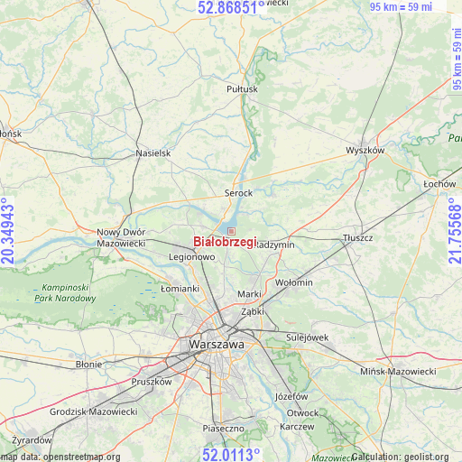
Białobrzegi GPS coordinates[2]
52° 26' 31.164" North, 21° 3' 9.18" East
| Map corner | latitude | longitude |
|---|---|---|
| Upper-left | 52.86851°, | 20.34943° |
| Center: | 52.44199°, | 21.05255° |
| Lower-right: | 52.0113°, | 21.75568° |
| Map W x H: | 95.3×95.3 km | = 59.2×59.2mi |
| max Lat: | 54.83135° ⇑24.5% North |
| Białobrzegi: | 52.44199° |
| min Lat: | ⇓75.5% South 49.21328° |
| min Long | Białobrzegi | max Long |
| 14.20249° | 21.05255° | 24.03723° |
| W 73.7%⇐ | ⇒26.3% E |
Elevation
Elevation of Białobrzegi is 84 m = 276 ft, and this is 107.4 m = 352 ft below average elevation for this country.
| Max E: |
974 m = 3196 ft | 87.2% |
| Avg. | 191.4 m = 628 ft | |
| Białobrzegi | 84 m = 276 ft | |
Min E: |
-3 m = -10 ft | 12.8% |
See also: Poland elevation on elevation.city.
Geographical zone
Białobrzegi is located in North temperate zone (between Tropic of Cancer and the Arctic Circle). Distance of this North polar circle is 1570.2 km =975.7 mi to North.| Distance of | km | miles | from Białobrzegi |
|---|---|---|---|
| North Pole | 4176.1 | 2594.9 | to North |
| Arctic Circle | 1570.2 | 975.7 | to North |
| Tropic Cancer | 3225.1 | 2004 | to South |
| Equator | 5831 | 3623.2 | to South |


Nearby cities:
15 places around Białobrzegi: (largest is in red/bold)
• Białołeka
14.5 km =9 mi,  202°
202°
• Czarna
14.3 km =8.9 mi,  124°
124°
• Jabłonna
11.5 km =7.1 mi,  232°
232°
• Kobyłka
15 km =9.3 mi,  139°
139°
• Legionowo
9.7 km =6 mi,  242°
242°
• Marki
13.9 km =8.6 mi,  165°
165°
• Michałów-Reginów
6.5 km =4 mi, 244°
• Nieporęt
1.8 km =1.1 mi, 229°
• Radzymin
9.4 km =5.8 mi,  107°
107°
• Serock
7.7 km =4.8 mi,  8°
8°
• Stanisławów
6.9 km =4.3 mi, 240°
• Stanisławów Pierwszy
7.5 km =4.7 mi,  180°
180°
• Słupno
9.5 km =5.9 mi,  132°
132°
• Wieliszew
5.8 km =3.6 mi,  280°
280°
• Łajski
7.1 km =4.4 mi,  258°
258°
Sources, notices
• [Note1] Compared only with cities in Poland existing in our database
• [Src1] Map data: © OpenStreetMap contributors (CC-BY-SA)
• [Src2] Other city data from geonames.org with taken over terms of usage.
• [Src3] Geographical zone / Annual Mean Temperature by Robert A. Rohde @ Wikipedia
