Śniadowo geodata
Śniadowo (Podlasie) is a populated place; located in Poland in Europe/Warsaw (GMT+2) time zone. With population of 1,500 people, there are 1837 cities with bigger population in this country. Compared to other cities in Poland, 84.2% of cities are located further ↓South; 84.8% of cities are located further ←West and 67.8% of cities have higher elevation than Śniadowo. Note1


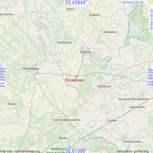
Śniadowo GPS coordinates[2]
53° 2' 19.464" North, 21° 59' 26.772" East
| Map corner | latitude | longitude |
|---|---|---|
| Upper-left | 53.45944°, | 21.28765° |
| Center: | 53.03874°, | 21.99077° |
| Lower-right: | 52.61389°, | 22.6939° |
| Map W x H: | 94×94 km | = 58.4×58.4mi |
| max Lat: | 54.83135° ⇑15.8% North |
| Śniadowo: | 53.03874° |
| min Lat: | ⇓84.2% South 49.21328° |
| min Long | Śniadowo | max Long |
| 14.20249° | 21.99077° | 24.03723° |
| W 84.8%⇐ | ⇒15.2% E |
Elevation
Elevation of Śniadowo is 126 m = 413 ft, and this is 65.4 m = 215 ft below average elevation for this country.
| Max E: |
974 m = 3196 ft | 67.8% |
| Avg. | 191.4 m = 628 ft | |
| Śniadowo | 126 m = 413 ft | |
Min E: |
-3 m = -10 ft | 32.2% |
See also: Poland elevation on elevation.city.
Geographical zone
Śniadowo is located in North temperate zone (between Tropic of Cancer and the Arctic Circle). Distance of this North polar circle is 1503.8 km =934.4 mi to North.| Distance of | km | miles | from Śniadowo |
|---|---|---|---|
| North Pole | 4109.7 | 2553.6 | to North |
| Arctic Circle | 1503.8 | 934.4 | to North |
| Tropic Cancer | 3291.4 | 2045.2 | to South |
| Equator | 5897.4 | 3664.5 | to South |


Nearby cities:
15 places around Śniadowo: (largest is in red/bold)
• Andrzejewo
27.1 km =16.8 mi,  148°
148°
• Czarnocin
20.3 km =12.6 mi,  16°
16°
• Czerwin
18.5 km =11.5 mi,  237°
237°
• Gać
17.7 km =11 mi,  75°
75°
• Miastkowo
17.1 km =10.6 mi,  316°
316°
• Nowogród
22.2 km =13.8 mi,  340°
340°
• Ostrów Mazowiecka
27 km =16.8 mi,  193°
193°
• Piątnica
18.9 km =11.7 mi, 21°
• Rzekuń
24.8 km =15.4 mi,  272°
272°
• Szumowo
14.7 km =9.1 mi, 154°
• Troszyn
17.4 km =10.8 mi, 267°
• Wąsewo
28.1 km =17.5 mi,  229°
229°
• Zambrów
17.9 km =11.1 mi,  109°
109°
• Zbójna
26.4 km =16.4 mi,  329°
329°
• Łomża
16.2 km =10.1 mi, 16°
Sources, notices
• [Note1] Compared only with cities in Poland existing in our database
• [Src1] Map data: © OpenStreetMap contributors (CC-BY-SA)
• [Src2] Other city data from geonames.org with taken over terms of usage.
• [Src3] Geographical zone / Annual Mean Temperature by Robert A. Rohde @ Wikipedia
