Rzekuń geodata
Rzekuń (Mazovia) is a seat of a third-order administrative division; located in Poland in Europe/Warsaw (GMT+2) time zone. With population of 1,800 people, there are 1605 cities with bigger population in this country. Compared to other cities in Poland, 84.2% of cities are located further ↓South; 80.4% of cities are located further ←West and 77.6% of cities have higher elevation than Rzekuń. Note1


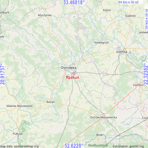
Rzekuń GPS coordinates[2]
53° 2' 51.216" North, 21° 37' 14.484" East
| Map corner | latitude | longitude |
|---|---|---|
| Upper-left | 53.46818°, | 20.91757° |
| Center: | 53.04756°, | 21.62069° |
| Lower-right: | 52.6228°, | 22.32382° |
| Map W x H: | 94×94 km | = 58.4×58.4mi |
| max Lat: | 54.83135° ⇑15.8% North |
| Rzekuń: | 53.04756° |
| min Lat: | ⇓84.2% South 49.21328° |
| min Long | Rzekuń | max Long |
| 14.20249° | 21.62069° | 24.03723° |
| W 80.4%⇐ | ⇒19.6% E |
Elevation
Elevation of Rzekuń is 104 m = 341 ft, and this is 87.4 m = 287 ft below average elevation for this country.
| Max E: |
974 m = 3196 ft | 77.6% |
| Avg. | 191.4 m = 628 ft | |
| Rzekuń | 104 m = 341 ft | |
Min E: |
-3 m = -10 ft | 22.4% |
See also: Poland elevation on elevation.city.
Geographical zone
Rzekuń is located in North temperate zone (between Tropic of Cancer and the Arctic Circle). Distance of this North polar circle is 1502.8 km =933.8 mi to North.| Distance of | km | miles | from Rzekuń |
|---|---|---|---|
| North Pole | 4108.7 | 2553 | to North |
| Arctic Circle | 1502.8 | 933.8 | to North |
| Tropic Cancer | 3292.4 | 2045.8 | to South |
| Equator | 5898.3 | 3665 | to South |


Nearby cities:
15 places around Rzekuń: (largest is in red/bold)
• Baranowo
25.8 km =16 mi,  303°
303°
• Czerwin
14.3 km =8.9 mi,  139°
139°
• Goworowo
16.9 km =10.5 mi,  194°
194°
• Kadzidło
23.2 km =14.4 mi,  333°
333°
• Lelis
15.5 km =9.6 mi,  344°
344°
• Miastkowo
17.3 km =10.7 mi,  48°
48°
• Młynarze
17.4 km =10.8 mi,  233°
233°
• Olszewo Borki
6.1 km =3.8 mi,  291°
291°
• Ostrołęka
5.2 km =3.2 mi, 325°
• Różan
23.5 km =14.6 mi,  220°
220°
• Sypniewo
21.5 km =13.4 mi,  257°
257°
• Troszyn
7.6 km =4.7 mi,  103°
103°
• Wąsewo
19.6 km =12.2 mi,  169°
169°
• Zbójna
24.4 km =15.2 mi,  27°
27°
• Śniadowo
24.8 km =15.4 mi,  92°
92°
Sources, notices
• [Note1] Compared only with cities in Poland existing in our database
• [Src1] Map data: © OpenStreetMap contributors (CC-BY-SA)
• [Src2] Other city data from geonames.org with taken over terms of usage.
• [Src3] Geographical zone / Annual Mean Temperature by Robert A. Rohde @ Wikipedia
