Miastkowo geodata
Miastkowo (Podlasie) is a populated place; located in Poland in Europe/Warsaw (GMT+2) time zone. With population of 1,000 people, there are 2459 cities with bigger population in this country. Compared to other cities in Poland, 85.7% of cities are located further ↓South; 82.5% of cities are located further ←West and 76.4% of cities have higher elevation than Miastkowo. Note1


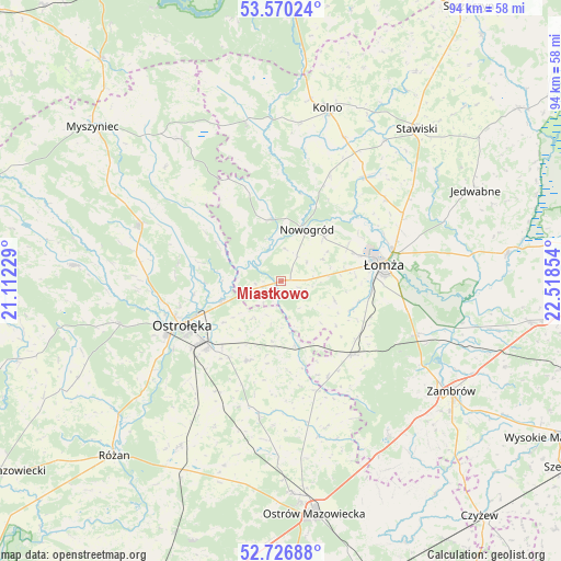
Miastkowo GPS coordinates[2]
53° 9' 2.268" North, 21° 48' 55.476" East
| Map corner | latitude | longitude |
|---|---|---|
| Upper-left | 53.57024°, | 21.11229° |
| Center: | 53.15063°, | 21.81541° |
| Lower-right: | 52.72688°, | 22.51854° |
| Map W x H: | 93.8×93.8 km | = 58.3×58.3mi |
| max Lat: | 54.83135° ⇑14.3% North |
| Miastkowo: | 53.15063° |
| min Lat: | ⇓85.7% South 49.21328° |
| min Long | Miastkowo | max Long |
| 14.20249° | 21.81541° | 24.03723° |
| W 82.5%⇐ | ⇒17.5% E |
Elevation
Elevation of Miastkowo is 107 m = 351 ft, and this is 84.4 m = 277 ft below average elevation for this country.
| Max E: |
974 m = 3196 ft | 76.4% |
| Avg. | 191.4 m = 628 ft | |
| Miastkowo | 107 m = 351 ft | |
Min E: |
-3 m = -10 ft | 23.6% |
See also: Poland elevation on elevation.city.
Geographical zone
Miastkowo is located in North temperate zone (between Tropic of Cancer and the Arctic Circle). Distance of this North polar circle is 1491.4 km =926.7 mi to North.| Distance of | km | miles | from Miastkowo |
|---|---|---|---|
| North Pole | 4097.3 | 2545.9 | to North |
| Arctic Circle | 1491.4 | 926.7 | to North |
| Tropic Cancer | 3303.9 | 2052.9 | to South |
| Equator | 5909.8 | 3672.2 | to South |


Nearby cities:
15 places around Miastkowo: (largest is in red/bold)
• Czarnocin
18.8 km =11.7 mi,  68°
68°
• Czerwin
22.7 km =14.1 mi,  189°
189°
• Janowo
23.4 km =14.5 mi,  16°
16°
• Kadzidło
25.2 km =15.7 mi,  291°
291°
• Lelis
17.5 km =10.9 mi,  281°
281°
• Mały Płock
22.2 km =13.8 mi,  39°
39°
• Nowogród
9.6 km =6 mi,  27°
27°
• Olszewo Borki
20.8 km =12.9 mi,  243°
243°
• Ostrołęka
17.5 km =10.9 mi,  245°
245°
• Piątnica
19.4 km =12.1 mi, 74°
• Rzekuń
17.3 km =10.7 mi,  228°
228°
• Troszyn
14.4 km =8.9 mi,  203°
203°
• Zbójna
10.4 km =6.5 mi,  349°
349°
• Łomża
16.5 km =10.3 mi,  79°
79°
• Śniadowo
17.1 km =10.6 mi,  136°
136°
Sources, notices
• [Note1] Compared only with cities in Poland existing in our database
• [Src1] Map data: © OpenStreetMap contributors (CC-BY-SA)
• [Src2] Other city data from geonames.org with taken over terms of usage.
• [Src3] Geographical zone / Annual Mean Temperature by Robert A. Rohde @ Wikipedia
