Łomża geodata
Łomża (Podlasie) is a populated place; located in Poland in Europe/Warsaw (GMT+2) time zone. With population of 63,723 people, there are 78 cities with bigger population in this country. Compared to other cities in Poland, 86.1% of cities are located further ↓South; 85.6% of cities are located further ←West and 78.4% of cities have higher elevation than Łomża. Note1


Łomża GPS coordinates[2]
53° 10' 41.016" North, 22° 3' 33.66" East
| Map corner | latitude | longitude |
|---|---|---|
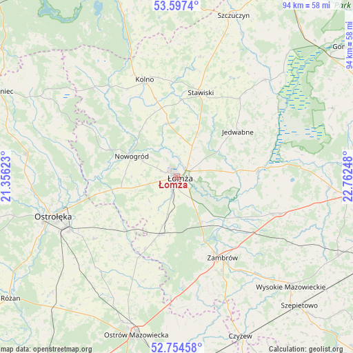
| Upper-left | 53.5974°, | 21.35623° |
| Center: | 53.17806°, | 22.05935° |
| Lower-right: | 52.75458°, | 22.76248° |
| Map W x H: | 93.7×93.7 km | = 58.2×58.2mi |
| max Lat: | 54.83135° ⇑13.9% North |
| Łomża: | 53.17806° |
| min Lat: | ⇓86.1% South 49.21328° |
| min Long | Łomża | max Long |
| 14.20249° | 22.05935° | 24.03723° |
| W 85.6%⇐ | ⇒14.4% E |
Elevation
Elevation of Łomża is 103 m = 338 ft, and this is 88.4 m = 290 ft below average elevation for this country.
| Max E: |
974 m = 3196 ft | 78.4% |
| Avg. | 191.4 m = 628 ft | |
| Łomża | 103 m = 338 ft | |
Min E: |
-3 m = -10 ft | 21.6% |
See also: Łomża elevation on elevation.city.
Geographical zone
Łomża is located in North temperate zone (between Tropic of Cancer and the Arctic Circle). Distance of this North polar circle is 1488.3 km =924.8 mi to North.| Distance of | km | miles | from Łomża |
|---|---|---|---|
| North Pole | 4094.2 | 2544 | to North |
| Arctic Circle | 1488.3 | 924.8 | to North |
| Tropic Cancer | 3306.9 | 2054.8 | to South |
| Equator | 5912.8 | 3674 | to South |


Nearby cities:
15 places around Łomża: (largest is in red/bold)
• Czarnocin
4.1 km =2.5 mi,  16°
16°
• Gać
16.6 km =10.3 mi,  131°
131°
• Janowo
21.5 km =13.4 mi,  334°
334°
• Jedwabne
20.2 km =12.6 mi,  53°
53°
• Mały Płock
14.1 km =8.8 mi,  351°
351°
• Miastkowo
16.5 km =10.3 mi,  259°
259°
• Nowogród
13 km =8.1 mi,  294°
294°
• Piątnica
3.2 km =2 mi, 49°
• Rutki
26.4 km =16.4 mi,  109°
109°
• Rutki-Kossaki
27.2 km =16.9 mi, 111°
• Stawiski
23.3 km =14.5 mi, 15°
• Wizna
21.6 km =13.4 mi,  84°
84°
• Zambrów
24.7 km =15.3 mi,  150°
150°
• Zbójna
19.4 km =12.1 mi, 291°
• Śniadowo
16.2 km =10.1 mi,  196°
196°
Sources, notices
• [Note1] Compared only with cities in Poland existing in our database
• [Src1] Map data: © OpenStreetMap contributors (CC-BY-SA)
• [Src2] Other city data from geonames.org with taken over terms of usage.
• [Src3] Geographical zone / Annual Mean Temperature by Robert A. Rohde @ Wikipedia
