Czerwin geodata
Czerwin (Mazovia) is a seat of a third-order administrative division; located in Poland in Europe/Warsaw (GMT+2) time zone. With population of 700 people, there are 3061 cities with bigger population in this country. Compared to other cities in Poland, 82.9% of cities are located further ↓South; 81.8% of cities are located further ←West and 76.4% of cities have higher elevation than Czerwin. Note1


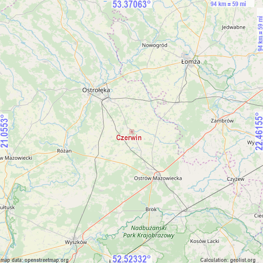
Czerwin GPS coordinates[2]
52° 56' 56.58" North, 21° 45' 30.312" East
| Map corner | latitude | longitude |
|---|---|---|
| Upper-left | 53.37063°, | 21.0553° |
| Center: | 52.94905°, | 21.75842° |
| Lower-right: | 52.52332°, | 22.46155° |
| Map W x H: | 94.2×94.2 km | = 58.5×58.5mi |
| max Lat: | 54.83135° ⇑17.1% North |
| Czerwin: | 52.94905° |
| min Lat: | ⇓82.9% South 49.21328° |
| min Long | Czerwin | max Long |
| 14.20249° | 21.75842° | 24.03723° |
| W 81.8%⇐ | ⇒18.2% E |
Elevation
Elevation of Czerwin is 107 m = 351 ft, and this is 84.4 m = 277 ft below average elevation for this country.
| Max E: |
974 m = 3196 ft | 76.4% |
| Avg. | 191.4 m = 628 ft | |
| Czerwin | 107 m = 351 ft | |
Min E: |
-3 m = -10 ft | 23.6% |
See also: Poland elevation on elevation.city.
Geographical zone
Czerwin is located in North temperate zone (between Tropic of Cancer and the Arctic Circle). Distance of this North polar circle is 1513.8 km =940.6 mi to North.| Distance of | km | miles | from Czerwin |
|---|---|---|---|
| North Pole | 4119.7 | 2559.9 | to North |
| Arctic Circle | 1513.8 | 940.6 | to North |
| Tropic Cancer | 3281.5 | 2039 | to South |
| Equator | 5887.4 | 3658.3 | to South |


Nearby cities:
15 places around Czerwin: (largest is in red/bold)
• Brok
28.5 km =17.7 mi,  166°
166°
• Długosiodło
23.8 km =14.8 mi,  208°
208°
• Goworowo
14.6 km =9.1 mi,  248°
248°
• Lelis
29.1 km =18.1 mi,  332°
332°
• Miastkowo
22.7 km =14.1 mi,  9°
9°
• Młynarze
23.3 km =14.5 mi,  271°
271°
• Olszewo Borki
19.9 km =12.4 mi,  311°
311°
• Ostrołęka
19.5 km =12.1 mi,  321°
321°
• Ostrów Mazowiecka
18.7 km =11.6 mi,  150°
150°
• Rzekuń
14.3 km =8.9 mi, 319°
• Różan
25.6 km =15.9 mi, 254°
• Szumowo
22.1 km =13.7 mi,  98°
98°
• Troszyn
9.3 km =5.8 mi,  348°
348°
• Wąsewo
10.1 km =6.3 mi, 214°
• Śniadowo
18.5 km =11.5 mi,  57°
57°
Sources, notices
• [Note1] Compared only with cities in Poland existing in our database
• [Src1] Map data: © OpenStreetMap contributors (CC-BY-SA)
• [Src2] Other city data from geonames.org with taken over terms of usage.
• [Src3] Geographical zone / Annual Mean Temperature by Robert A. Rohde @ Wikipedia
