Siedliska geodata
Siedliska (Lesser Poland) is a populated place; located in Poland in Europe/Warsaw (GMT+2) time zone. With population of 2,351 people, there are 1301 cities with bigger population in this country. Compared to other cities in Poland, 88.9% of cities are located further ↑North; 72.6% of cities are located further ←West and 73.4% of cities have lower elevation than Siedliska. Note1


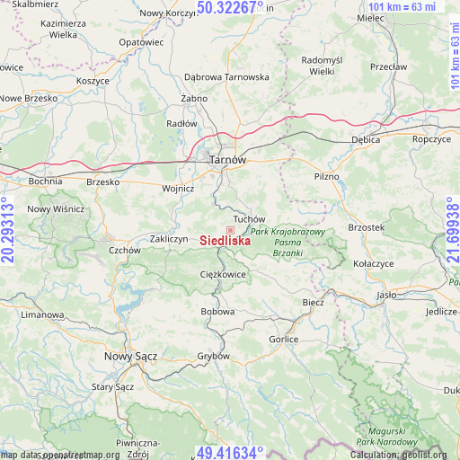
Siedliska GPS coordinates[2]
49° 52' 17.868" North, 20° 59' 46.5" East
| Map corner | latitude | longitude |
|---|---|---|
| Upper-left | 50.32267°, | 20.29313° |
| Center: | 49.87163°, | 20.99625° |
| Lower-right: | 49.41634°, | 21.69938° |
| Map W x H: | 100.8×100.8 km | = 62.6×62.6mi |
| max Lat: | 54.83135° ⇑88.9% North |
| Siedliska: | 49.87163° |
| min Lat: | ⇓11.1% South 49.21328° |
| min Long | Siedliska | max Long |
| 14.20249° | 20.99625° | 24.03723° |
| W 72.6%⇐ | ⇒27.4% E |
Elevation
Elevation of Siedliska is 241 m = 791 ft, and this is 49.6 m = 163 ft above average elevation for this country.
| Max E: |
974 m = 3196 ft | 26.6% |
| Siedliska | 241 m 791 ft | |
| Avg. | 191.4 m = 628 ft | |
Min E: |
-3 m = -10 ft | 73.4% |
See also: Poland elevation on elevation.city.
Geographical zone
Siedliska is located in North temperate zone (between Tropic of Cancer and the Arctic Circle). Distance of this North polar circle is 1856 km =1153.3 mi to North.| Distance of | km | miles | from Siedliska |
|---|---|---|---|
| North Pole | 4461.9 | 2772.5 | to North |
| Arctic Circle | 1856 | 1153.3 | to North |
| Tropic Cancer | 2939.3 | 1826.4 | to South |
| Equator | 5545.2 | 3445.6 | to South |


Nearby cities:
15 places around Siedliska: (largest is in red/bold)
• Błonie
11.1 km =6.9 mi,  323°
323°
• Ciężkowice
9.7 km =6 mi,  189°
189°
• Gromnik
4.5 km =2.8 mi,  214°
214°
• Janowice
10 km =6.2 mi,  282°
282°
• Jastrzębia
11.7 km =7.3 mi,  225°
225°
• Karwodrza
8.2 km =5.1 mi,  42°
42°
• Lubaszowa
3.2 km =2 mi,  114°
114°
• Pleśna
7.1 km =4.4 mi,  329°
329°
• Rychwałd
5.7 km =3.5 mi,  313°
313°
• Ryglice
10.2 km =6.3 mi,  85°
85°
• Rzepiennik Marciszewski
4.6 km =2.9 mi,  172°
172°
• Rzepiennik Strzyżewski
7.9 km =4.9 mi,  158°
158°
• Siemiechów
6.8 km =4.2 mi,  252°
252°
• Tuchów
4.9 km =3 mi,  58°
58°
• Wróblowice
10.2 km =6.3 mi,  273°
273°
Sources, notices
• [Note1] Compared only with cities in Poland existing in our database
• [Src1] Map data: © OpenStreetMap contributors (CC-BY-SA)
• [Src2] Other city data from geonames.org with taken over terms of usage.
• [Src3] Geographical zone / Annual Mean Temperature by Robert A. Rohde @ Wikipedia
