Karwodrza geodata
Karwodrza (Lesser Poland) is a populated place; located in Poland in Europe/Warsaw (GMT+2) time zone. With population of 937 people, there are 2613 cities with bigger population in this country. Compared to other cities in Poland, 86.5% of cities are located further ↑North; 74% of cities are located further ←West and 77.9% of cities have lower elevation than Karwodrza. Note1


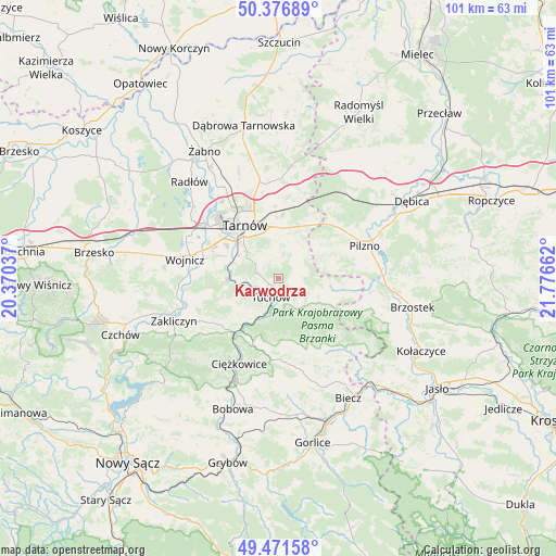
Karwodrza GPS coordinates[2]
49° 55' 34.896" North, 21° 4' 24.564" East
| Map corner | latitude | longitude |
|---|---|---|
| Upper-left | 50.37689°, | 20.37037° |
| Center: | 49.92636°, | 21.07349° |
| Lower-right: | 49.47158°, | 21.77662° |
| Map W x H: | 100.7×100.7 km | = 62.6×62.6mi |
| max Lat: | 54.83135° ⇑86.5% North |
| Karwodrza: | 49.92636° |
| min Lat: | ⇓13.5% South 49.21328° |
| min Long | Karwodrza | max Long |
| 14.20249° | 21.07349° | 24.03723° |
| W 74%⇐ | ⇒26% E |
Elevation
Elevation of Karwodrza is 257 m = 843 ft, and this is 65.6 m = 215 ft above average elevation for this country.
| Max E: |
974 m = 3196 ft | 22.1% |
| Karwodrza | 257 m 843 ft | |
| Avg. | 191.4 m = 628 ft | |
Min E: |
-3 m = -10 ft | 77.9% |
See also: Poland elevation on elevation.city.
Geographical zone
Karwodrza is located in North temperate zone (between Tropic of Cancer and the Arctic Circle). Distance of this North polar circle is 1849.9 km =1149.5 mi to North.| Distance of | km | miles | from Karwodrza |
|---|---|---|---|
| North Pole | 4455.8 | 2768.7 | to North |
| Arctic Circle | 1849.9 | 1149.5 | to North |
| Tropic Cancer | 2945.4 | 1830.2 | to South |
| Equator | 5551.3 | 3449.4 | to South |


Nearby cities:
15 places around Karwodrza: (largest is in red/bold)
• Koszyce
10.7 km =6.6 mi,  298°
298°
• Koszyce Wielkie
11 km =6.8 mi, 303°
• Lubaszowa
7.9 km =4.9 mi,  199°
199°
• Pleśna
9.2 km =5.7 mi,  270°
270°
• Pogórska Wola
11.9 km =7.4 mi,  30°
30°
• Rychwałd
9.9 km =6.2 mi,  257°
257°
• Ryglice
7 km =4.3 mi,  139°
139°
• Rzepiennik Marciszewski
11.7 km =7.3 mi,  205°
205°
• Siedliska
8.2 km =5.1 mi,  222°
222°
• Skrzyszów
7.5 km =4.7 mi,  353°
353°
• Szynwałd
5.8 km =3.6 mi,  37°
37°
• Tarnowiec
8.7 km =5.4 mi,  314°
314°
• Tarnów
11.5 km =7.1 mi,  327°
327°
• Tuchów
3.8 km =2.4 mi, 201°
• Łęki Górne
8.9 km =5.5 mi,  53°
53°
Sources, notices
• [Note1] Compared only with cities in Poland existing in our database
• [Src1] Map data: © OpenStreetMap contributors (CC-BY-SA)
• [Src2] Other city data from geonames.org with taken over terms of usage.
• [Src3] Geographical zone / Annual Mean Temperature by Robert A. Rohde @ Wikipedia
