Tuchów geodata
Tuchów (Lesser Poland) is a seat of a third-order administrative division; located in Poland in Europe/Warsaw (GMT+2) time zone. With population of 6,680 people, there are 562 cities with bigger population in this country. Compared to other cities in Poland, 87.8% of cities are located further ↑North; 73.7% of cities are located further ←West and 70.6% of cities have lower elevation than Tuchów. Note1


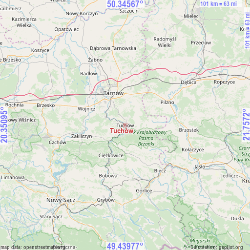
Tuchów GPS coordinates[2]
49° 53' 41.46" North, 21° 3' 14.652" East
| Map corner | latitude | longitude |
|---|---|---|
| Upper-left | 50.34567°, | 20.35095° |
| Center: | 49.89485°, | 21.05407° |
| Lower-right: | 49.43977°, | 21.7572° |
| Map W x H: | 100.7×100.7 km | = 62.6×62.6mi |
| max Lat: | 54.83135° ⇑87.8% North |
| Tuchów: | 49.89485° |
| min Lat: | ⇓12.2% South 49.21328° |
| min Long | Tuchów | max Long |
| 14.20249° | 21.05407° | 24.03723° |
| W 73.7%⇐ | ⇒26.3% E |
Elevation
Elevation of Tuchów is 231 m = 758 ft, and this is 39.6 m = 130 ft above average elevation for this country.
| Max E: |
974 m = 3196 ft | 29.4% |
| Tuchów | 231 m 758 ft | |
| Avg. | 191.4 m = 628 ft | |
Min E: |
-3 m = -10 ft | 70.6% |
See also: Poland elevation on elevation.city.
Geographical zone
Tuchów is located in North temperate zone (between Tropic of Cancer and the Arctic Circle). Distance of this North polar circle is 1853.4 km =1151.6 mi to North.| Distance of | km | miles | from Tuchów |
|---|---|---|---|
| North Pole | 4459.3 | 2770.9 | to North |
| Arctic Circle | 1853.4 | 1151.6 | to North |
| Tropic Cancer | 2941.9 | 1828 | to South |
| Equator | 5547.8 | 3447.2 | to South |


Nearby cities:
15 places around Tuchów: (largest is in red/bold)
• Gromnik
9.1 km =5.7 mi,  226°
226°
• Karwodrza
3.8 km =2.4 mi,  21°
21°
• Koszyce
11.8 km =7.3 mi,  316°
316°
• Lubaszowa
4.1 km =2.5 mi,  197°
197°
• Pleśna
8.5 km =5.3 mi,  294°
294°
• Rychwałd
8.4 km =5.2 mi,  278°
278°
• Ryglice
6.2 km =3.9 mi,  106°
106°
• Rzepiennik Marciszewski
8 km =5 mi,  206°
206°
• Rzepiennik Strzyżewski
10 km =6.2 mi,  187°
187°
• Siedliska
4.9 km =3 mi,  238°
238°
• Siemiechów
11.6 km =7.2 mi,  246°
246°
• Skrzyszów
11 km =6.8 mi,  2°
2°
• Szynwałd
9.5 km =5.9 mi,  31°
31°
• Tarnowiec
10.8 km =6.7 mi,  333°
333°
• Żurowa
11.2 km =7 mi,  132°
132°
Sources, notices
• [Note1] Compared only with cities in Poland existing in our database
• [Src1] Map data: © OpenStreetMap contributors (CC-BY-SA)
• [Src2] Other city data from geonames.org with taken over terms of usage.
• [Src3] Geographical zone / Annual Mean Temperature by Robert A. Rohde @ Wikipedia
