Ryglice geodata
Ryglice (Lesser Poland) is a seat of a third-order administrative division; located in Poland in Europe/Warsaw (GMT+2) time zone. With population of 2,802 people, there are 1118 cities with bigger population in this country. Compared to other cities in Poland, 88.5% of cities are located further ↑North; 74.9% of cities are located further ←West and 73.4% of cities have lower elevation than Ryglice. Note1


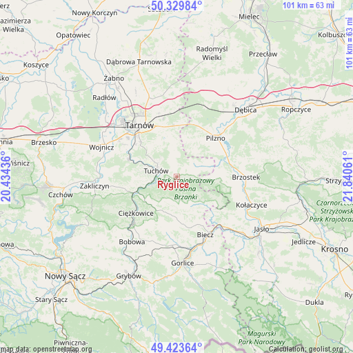
Ryglice GPS coordinates[2]
49° 52' 43.932" North, 21° 8' 14.928" East
| Map corner | latitude | longitude |
|---|---|---|
| Upper-left | 50.32984°, | 20.43436° |
| Center: | 49.87887°, | 21.13748° |
| Lower-right: | 49.42364°, | 21.84061° |
| Map W x H: | 100.8×100.8 km | = 62.6×62.6mi |
| max Lat: | 54.83135° ⇑88.5% North |
| Ryglice: | 49.87887° |
| min Lat: | ⇓11.5% South 49.21328° |
| min Long | Ryglice | max Long |
| 14.20249° | 21.13748° | 24.03723° |
| W 74.9%⇐ | ⇒25.1% E |
Elevation
Elevation of Ryglice is 241 m = 791 ft, and this is 49.6 m = 163 ft above average elevation for this country.
| Max E: |
974 m = 3196 ft | 26.6% |
| Ryglice | 241 m 791 ft | |
| Avg. | 191.4 m = 628 ft | |
Min E: |
-3 m = -10 ft | 73.4% |
See also: Poland elevation on elevation.city.
Geographical zone
Ryglice is located in North temperate zone (between Tropic of Cancer and the Arctic Circle). Distance of this North polar circle is 1855.2 km =1152.8 mi to North.| Distance of | km | miles | from Ryglice |
|---|---|---|---|
| North Pole | 4461.1 | 2772 | to North |
| Arctic Circle | 1855.2 | 1152.8 | to North |
| Tropic Cancer | 2940.1 | 1826.9 | to South |
| Equator | 5546 | 3446.1 | to South |


Nearby cities:
15 places around Ryglice: (largest is in red/bold)
• Gromnik
13.4 km =8.3 mi,  250°
250°
• Jodłowa
10.2 km =6.3 mi,  94°
94°
• Karwodrza
7 km =4.3 mi,  319°
319°
• Lubaszowa
7.5 km =4.7 mi, 253°
• Ołpiny
9.3 km =5.8 mi,  148°
148°
• Rzepiennik Marciszewski
11 km =6.8 mi,  240°
240°
• Rzepiennik Strzyżewski
10.9 km =6.8 mi,  221°
221°
• Siedliska
10.2 km =6.3 mi,  265°
265°
• Szerzyny
11 km =6.8 mi,  134°
134°
• Szynwałd
9.9 km =6.2 mi,  353°
353°
• Słotowa
13.5 km =8.4 mi,  56°
56°
• Tuchów
6.2 km =3.9 mi,  286°
286°
• Łęki Dolne
13.2 km =8.2 mi,  36°
36°
• Łęki Górne
10.9 km =6.8 mi,  13°
13°
• Żurowa
6.3 km =3.9 mi,  158°
158°
Sources, notices
• [Note1] Compared only with cities in Poland existing in our database
• [Src1] Map data: © OpenStreetMap contributors (CC-BY-SA)
• [Src2] Other city data from geonames.org with taken over terms of usage.
• [Src3] Geographical zone / Annual Mean Temperature by Robert A. Rohde @ Wikipedia
