Brzesko geodata
Brzesko (Lesser Poland) is a seat of a second-order administrative division; located in Poland in Europe/Warsaw (GMT+2) time zone. With population of 16,866 people, there are 292 cities with bigger population in this country. Compared to other cities in Poland, 84.4% of cities are located further ↑North; 66.4% of cities are located further ←West and 68.7% of cities have lower elevation than Brzesko. Note1


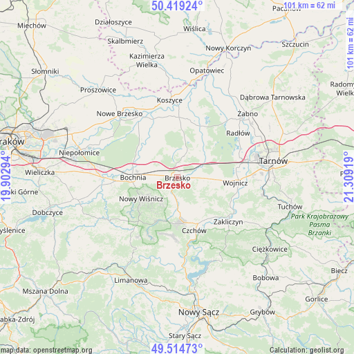
Brzesko GPS coordinates[2]
49° 58' 8.796" North, 20° 36' 21.816" East
| Map corner | latitude | longitude |
|---|---|---|
| Upper-left | 50.41924°, | 19.90294° |
| Center: | 49.96911°, | 20.60606° |
| Lower-right: | 49.51473°, | 21.30919° |
| Map W x H: | 100.6×100.6 km | = 62.5×62.5mi |
| max Lat: | 54.83135° ⇑84.4% North |
| Brzesko: | 49.96911° |
| min Lat: | ⇓15.6% South 49.21328° |
| min Long | Brzesko | max Long |
| 14.20249° | 20.60606° | 24.03723° |
| W 66.4%⇐ | ⇒33.6% E |
Elevation
Elevation of Brzesko is 225 m = 738 ft, and this is 33.6 m = 110 ft above average elevation for this country.
| Max E: |
974 m = 3196 ft | 31.3% |
| Brzesko | 225 m 738 ft | |
| Avg. | 191.4 m = 628 ft | |
Min E: |
-3 m = -10 ft | 68.7% |
See also: Poland elevation on elevation.city.
Geographical zone
Brzesko is located in North temperate zone (between Tropic of Cancer and the Arctic Circle). Distance of this North polar circle is 1845.1 km =1146.5 mi to North.| Distance of | km | miles | from Brzesko |
|---|---|---|---|
| North Pole | 4451 | 2765.7 | to North |
| Arctic Circle | 1845.1 | 1146.5 | to North |
| Tropic Cancer | 2950.1 | 1833.1 | to South |
| Equator | 5556 | 3452.3 | to South |


Nearby cities:
15 places around Brzesko: (largest is in red/bold)
• Borek
7.6 km =4.7 mi,  315°
315°
• Dębno
8.1 km =5 mi,  91°
91°
• Jadowniki
3 km =1.9 mi,  112°
112°
• Jasień
2.4 km =1.5 mi,  272°
272°
• Jodłówka
4.9 km =3 mi,  302°
302°
• Maszkienice
6.2 km =3.9 mi,  68°
68°
• Okocim
2.3 km =1.4 mi,  188°
188°
• Porąbka Uszewska
6.7 km =4.2 mi,  116°
116°
• Poręba Spytkowska
4.9 km =3 mi,  228°
228°
• Przyborów
7.9 km =4.9 mi,  30°
30°
• Rzezawa
6.9 km =4.3 mi,  289°
289°
• Sterkowiec
6.1 km =3.8 mi,  61°
61°
• Szczepanów
5.3 km =3.3 mi,  40°
40°
• Wokowice
7.9 km =4.9 mi, 58°
• Wola Dębińska
6 km =3.7 mi,  76°
76°
Sources, notices
• [Note1] Compared only with cities in Poland existing in our database
• [Src1] Map data: © OpenStreetMap contributors (CC-BY-SA)
• [Src2] Other city data from geonames.org with taken over terms of usage.
• [Src3] Geographical zone / Annual Mean Temperature by Robert A. Rohde @ Wikipedia
