Jasień geodata
Jasień (Lesser Poland) is a populated place; located in Poland in Europe/Warsaw (GMT+2) time zone. With population of 2,934 people, there are 1077 cities with bigger population in this country. Compared to other cities in Poland, 84.3% of cities are located further ↑North; 66% of cities are located further ←West and 77% of cities have lower elevation than Jasień. Note1


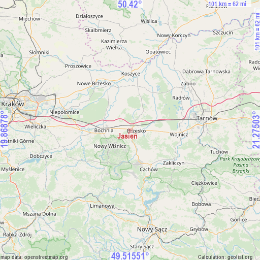
Jasień GPS coordinates[2]
49° 58' 11.568" North, 20° 34' 18.84" East
| Map corner | latitude | longitude |
|---|---|---|
| Upper-left | 50.42°, | 19.86878° |
| Center: | 49.96988°, | 20.5719° |
| Lower-right: | 49.51551°, | 21.27503° |
| Map W x H: | 100.6×100.6 km | = 62.5×62.5mi |
| max Lat: | 54.83135° ⇑84.3% North |
| Jasień: | 49.96988° |
| min Lat: | ⇓15.7% South 49.21328° |
| min Long | Jasień | max Long |
| 14.20249° | 20.5719° | 24.03723° |
| W 66%⇐ | ⇒34% E |
Elevation
Elevation of Jasień is 254 m = 833 ft, and this is 62.6 m = 205 ft above average elevation for this country.
| Max E: |
974 m = 3196 ft | 23% |
| Jasień | 254 m 833 ft | |
| Avg. | 191.4 m = 628 ft | |
Min E: |
-3 m = -10 ft | 77% |
See also: Poland elevation on elevation.city.
Geographical zone
Jasień is located in North temperate zone (between Tropic of Cancer and the Arctic Circle). Distance of this North polar circle is 1845 km =1146.4 mi to North.| Distance of | km | miles | from Jasień |
|---|---|---|---|
| North Pole | 4450.9 | 2765.7 | to North |
| Arctic Circle | 1845 | 1146.4 | to North |
| Tropic Cancer | 2950.2 | 1833.2 | to South |
| Equator | 5556.1 | 3452.4 | to South |


Nearby cities:
15 places around Jasień: (largest is in red/bold)
• Borek
6.1 km =3.8 mi,  331°
331°
• Brzesko
2.4 km =1.5 mi,  92°
92°
• Brzeźnica
5.9 km =3.7 mi,  256°
256°
• Gnojnik
8.8 km =5.5 mi,  162°
162°
• Jadowniki
5.3 km =3.3 mi,  103°
103°
• Jodłówka
3.1 km =1.9 mi, 326°
• Krzeczów
6.4 km =4 mi,  289°
289°
• Maszkienice
8.5 km =5.3 mi,  75°
75°
• Okocim
3.2 km =2 mi,  137°
137°
• Poręba Spytkowska
3.6 km =2.2 mi,  200°
200°
• Rzezawa
4.6 km =2.9 mi,  298°
298°
• Stary Wiśnicz
7.9 km =4.9 mi,  231°
231°
• Sterkowiec
8.3 km =5.2 mi,  70°
70°
• Szczepanów
7.1 km =4.4 mi,  56°
56°
• Wola Dębińska
8.4 km =5.2 mi, 80°
Sources, notices
• [Note1] Compared only with cities in Poland existing in our database
• [Src1] Map data: © OpenStreetMap contributors (CC-BY-SA)
• [Src2] Other city data from geonames.org with taken over terms of usage.
• [Src3] Geographical zone / Annual Mean Temperature by Robert A. Rohde @ Wikipedia
