Rzeczyca geodata
Rzeczyca (Łódź Voivodeship) is a seat of a third-order administrative division; located in Poland in Europe/Warsaw (GMT+2) time zone. With population of 1,589 people, there are 1781 cities with bigger population in this country. Compared to other cities in Poland, 57.9% of cities are located further ↓South; 62.5% of cities are located further ←West and 52.9% of cities have higher elevation than Rzeczyca. Note1


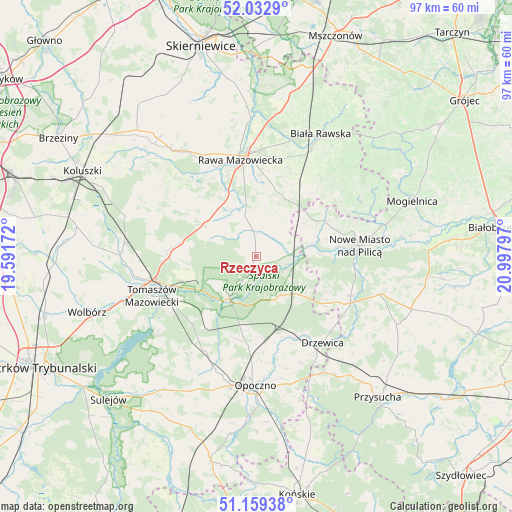
Rzeczyca GPS coordinates[2]
51° 35' 53.664" North, 20° 17' 41.424" East
| Map corner | latitude | longitude |
|---|---|---|
| Upper-left | 52.0329°, | 19.59172° |
| Center: | 51.59824°, | 20.29484° |
| Lower-right: | 51.15938°, | 20.99797° |
| Map W x H: | 97.1×97.1 km | = 60.3×60.3mi |
| max Lat: | 54.83135° ⇑42.1% North |
| Rzeczyca: | 51.59824° |
| min Lat: | ⇓57.9% South 49.21328° |
| min Long | Rzeczyca | max Long |
| 14.20249° | 20.29484° | 24.03723° |
| W 62.5%⇐ | ⇒37.5% E |
Elevation
Elevation of Rzeczyca is 164 m = 538 ft, and this is 27.4 m = 90 ft below average elevation for this country.
| Max E: |
974 m = 3196 ft | 52.9% |
| Avg. | 191.4 m = 628 ft | |
| Rzeczyca | 164 m = 538 ft | |
Min E: |
-3 m = -10 ft | 47.1% |
See also: Poland elevation on elevation.city.
Geographical zone
Rzeczyca is located in North temperate zone (between Tropic of Cancer and the Arctic Circle). Distance of this North polar circle is 1664 km =1034 mi to North.| Distance of | km | miles | from Rzeczyca |
|---|---|---|---|
| North Pole | 4269.9 | 2653.2 | to North |
| Arctic Circle | 1664 | 1034 | to North |
| Tropic Cancer | 3131.3 | 1945.7 | to South |
| Equator | 5737.2 | 3564.9 | to South |


Nearby cities:
15 places around Rzeczyca: (largest is in red/bold)
• Bukowiec Opoczyński
20.3 km =12.6 mi,  185°
185°
• Cielądz
13.5 km =8.4 mi,  14°
14°
• Czerniewice
11.5 km =7.1 mi,  302°
302°
• Drzewica
20.7 km =12.9 mi,  142°
142°
• Inowłódz
9.3 km =5.8 mi,  212°
212°
• Lubochnia
16.7 km =10.4 mi,  273°
273°
• Nowe Miasto nad Pilicą
19.6 km =12.2 mi,  83°
83°
• Odrzywół
20 km =12.4 mi,  115°
115°
• Poświętne
8.8 km =5.5 mi,  146°
146°
• Rawa Mazowiecka
18.7 km =11.6 mi,  351°
351°
• Regnów
17.9 km =11.1 mi,  20°
20°
• Sadkowice
20.7 km =12.9 mi,  47°
47°
• Tomaszów Mazowiecki
21.1 km =13.1 mi,  249°
249°
• Złota
21.5 km =13.4 mi,  333°
333°
• Żelechlinek
22 km =13.7 mi,  305°
305°
Sources, notices
• [Note1] Compared only with cities in Poland existing in our database
• [Src1] Map data: © OpenStreetMap contributors (CC-BY-SA)
• [Src2] Other city data from geonames.org with taken over terms of usage.
• [Src3] Geographical zone / Annual Mean Temperature by Robert A. Rohde @ Wikipedia
