Żelechlinek geodata
Żelechlinek (Łódź Voivodeship) is a seat of a third-order administrative division; located in Poland in Europe/Warsaw (GMT+2) time zone. With population of 474 people, there are 3552 cities with bigger population in this country. Compared to other cities in Poland, 60.3% of cities are located further ↓South; 58.9% of cities are located further ←West and 55.6% of cities have lower elevation than Żelechlinek. Note1
Administrative division(s):
- Level 1: Łódź Voivodeship
- Level 2: Powiat tomaszowski
- Level 3: Żelechlinek


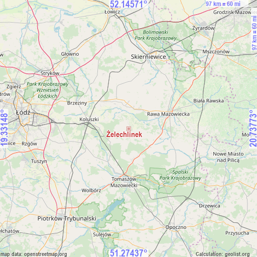
Żelechlinek GPS coordinates[2]
51° 42' 43.704" North, 20° 2' 4.56" East
| Map corner | latitude | longitude |
|---|---|---|
| Upper-left | 52.14571°, | 19.33148° |
| Center: | 51.71214°, | 20.0346° |
| Lower-right: | 51.27437°, | 20.73773° |
| Map W x H: | 96.9×96.9 km | = 60.2×60.2mi |
| max Lat: | 54.83135° ⇑39.7% North |
| Żelechlinek: | 51.71214° |
| min Lat: | ⇓60.3% South 49.21328° |
| min Long | Żelechlinek | max Long |
| 14.20249° | 20.0346° | 24.03723° |
| W 58.9%⇐ | ⇒41.1% E |
Elevation
Elevation of Żelechlinek is 187 m = 614 ft, and this is 4.4 m = 14 ft below average elevation for this country.
| Max E: |
974 m = 3196 ft | 44.4% |
| Avg. | 191.4 m = 628 ft | |
| Żelechlinek | 187 m = 614 ft | |
Min E: |
-3 m = -10 ft | 55.6% |
See also: Poland elevation on elevation.city.
Geographical zone
Żelechlinek is located in North temperate zone (between Tropic of Cancer and the Arctic Circle). Distance of this North polar circle is 1651.3 km =1026.1 mi to North.| Distance of | km | miles | from Żelechlinek |
|---|---|---|---|
| North Pole | 4257.2 | 2645.3 | to North |
| Arctic Circle | 1651.3 | 1026.1 | to North |
| Tropic Cancer | 3143.9 | 1953.5 | to South |
| Equator | 5749.9 | 3572.8 | to South |


Nearby cities:
15 places around Żelechlinek: (largest is in red/bold)
• Budziszewice
8.4 km =5.2 mi,  233°
233°
• Czerniewice
10.5 km =6.5 mi,  127°
127°
• Godzianów
20.5 km =12.7 mi,  0°
0°
• Głuchów
8 km =5 mi,  21°
21°
• Jeżów
12.2 km =7.6 mi,  338°
338°
• Koluszki
15.1 km =9.4 mi,  281°
281°
• Lubochnia
11.7 km =7.3 mi,  173°
173°
• Rawa Mazowiecka
16.2 km =10.1 mi,  69°
69°
• Rogów
15.5 km =9.6 mi,  319°
319°
• Rokiciny
17.4 km =10.8 mi,  246°
246°
• Rokiciny-Kolonia
18.1 km =11.2 mi, 253°
• Słupia
16.5 km =10.3 mi, 344°
• Tomaszów Mazowiecki
20.2 km =12.6 mi,  185°
185°
• Ujazd
14.9 km =9.3 mi,  211°
211°
• Złota
10.8 km =6.7 mi,  52°
52°
Sources, notices
• [Note1] Compared only with cities in Poland existing in our database
• [Src1] Map data: © OpenStreetMap contributors (CC-BY-SA)
• [Src2] Other city data from geonames.org with taken over terms of usage.
• [Src3] Geographical zone / Annual Mean Temperature by Robert A. Rohde @ Wikipedia
