Odrzywół geodata
Odrzywół (Mazovia) is a seat of a third-order administrative division; located in Poland in Europe/Warsaw (GMT+2) time zone. With population of 2,000 people, there are 1469 cities with bigger population in this country. Compared to other cities in Poland, 56.6% of cities are located further ↓South; 65.8% of cities are located further ←West and 60.3% of cities have higher elevation than Odrzywół. Note1


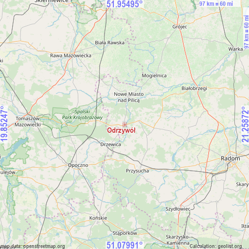
Odrzywół GPS coordinates[2]
51° 31' 10.308" North, 20° 33' 20.124" East
| Map corner | latitude | longitude |
|---|---|---|
| Upper-left | 51.95495°, | 19.85247° |
| Center: | 51.51953°, | 20.55559° |
| Lower-right: | 51.07991°, | 21.25872° |
| Map W x H: | 97.3×97.3 km | = 60.5×60.5mi |
| max Lat: | 54.83135° ⇑43.4% North |
| Odrzywół: | 51.51953° |
| min Lat: | ⇓56.6% South 49.21328° |
| min Long | Odrzywół | max Long |
| 14.20249° | 20.55559° | 24.03723° |
| W 65.8%⇐ | ⇒34.2% E |
Elevation
Elevation of Odrzywół is 146 m = 479 ft, and this is 45.4 m = 149 ft below average elevation for this country.
| Max E: |
974 m = 3196 ft | 60.3% |
| Avg. | 191.4 m = 628 ft | |
| Odrzywół | 146 m = 479 ft | |
Min E: |
-3 m = -10 ft | 39.7% |
See also: Poland elevation on elevation.city.
Geographical zone
Odrzywół is located in North temperate zone (between Tropic of Cancer and the Arctic Circle). Distance of this North polar circle is 1672.7 km =1039.4 mi to North.| Distance of | km | miles | from Odrzywół |
|---|---|---|---|
| North Pole | 4278.6 | 2658.6 | to North |
| Arctic Circle | 1672.7 | 1039.4 | to North |
| Tropic Cancer | 3122.5 | 1940.2 | to South |
| Equator | 5728.4 | 3559.5 | to South |


Nearby cities:
15 places around Odrzywół: (largest is in red/bold)
• Drzewica
9.4 km =5.8 mi,  215°
215°
• Gielniów
14.2 km =8.8 mi,  201°
201°
• Inowłódz
23 km =14.3 mi,  272°
272°
• Klwów
5.8 km =3.6 mi,  73°
73°
• Mogielnica
22.6 km =14 mi,  30°
30°
• Mroczków Gościnny
19.2 km =11.9 mi, 216°
• Nowe Miasto nad Pilicą
11.1 km =6.9 mi,  7°
7°
• Potworów
11.6 km =7.2 mi,  95°
95°
• Poświętne
13.3 km =8.3 mi,  276°
276°
• Przysucha
18.6 km =11.6 mi,  164°
164°
• Radzanów
21.7 km =13.5 mi,  78°
78°
• Rusinów
9.5 km =5.9 mi,  166°
166°
• Rzeczyca
20 km =12.4 mi,  295°
295°
• Wola Załężna
21.7 km =13.5 mi,  229°
229°
• Wyśmierzyce
21.4 km =13.3 mi,  56°
56°
Sources, notices
• [Note1] Compared only with cities in Poland existing in our database
• [Src1] Map data: © OpenStreetMap contributors (CC-BY-SA)
• [Src2] Other city data from geonames.org with taken over terms of usage.
• [Src3] Geographical zone / Annual Mean Temperature by Robert A. Rohde @ Wikipedia
