Regnów geodata
Regnów (Łódź Voivodeship) is a seat of a third-order administrative division; located in Poland in Europe/Warsaw (GMT+2) time zone. With population of 340 people, there are 3610 cities with bigger population in this country. Compared to other cities in Poland, 61.1% of cities are located further ↓South; 63.6% of cities are located further ←West and 53.3% of cities have higher elevation than Regnów. Note1


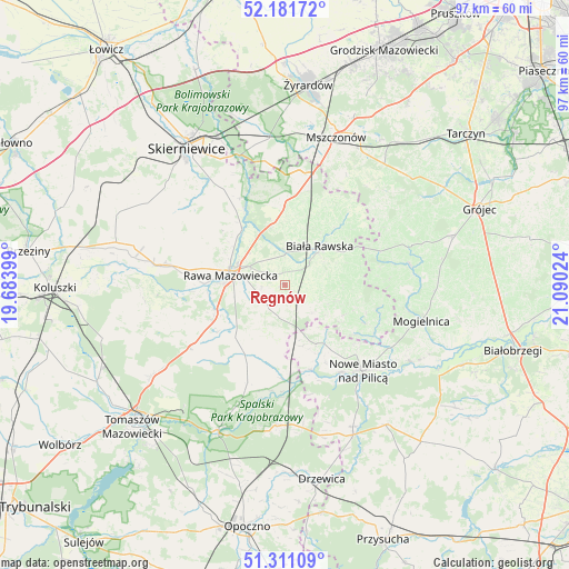
Regnów GPS coordinates[2]
51° 44' 54.6" North, 20° 23' 13.596" East
| Map corner | latitude | longitude |
|---|---|---|
| Upper-left | 52.18172°, | 19.68399° |
| Center: | 51.7485°, | 20.38711° |
| Lower-right: | 51.31109°, | 21.09024° |
| Map W x H: | 96.8×96.8 km | = 60.1×60.1mi |
| max Lat: | 54.83135° ⇑38.9% North |
| Regnów: | 51.7485° |
| min Lat: | ⇓61.1% South 49.21328° |
| min Long | Regnów | max Long |
| 14.20249° | 20.38711° | 24.03723° |
| W 63.6%⇐ | ⇒36.4% E |
Elevation
Elevation of Regnów is 163 m = 535 ft, and this is 28.4 m = 93 ft below average elevation for this country.
| Max E: |
974 m = 3196 ft | 53.3% |
| Avg. | 191.4 m = 628 ft | |
| Regnów | 163 m = 535 ft | |
Min E: |
-3 m = -10 ft | 46.7% |
See also: Poland elevation on elevation.city.
Geographical zone
Regnów is located in North temperate zone (between Tropic of Cancer and the Arctic Circle). Distance of this North polar circle is 1647.3 km =1023.6 mi to North.| Distance of | km | miles | from Regnów |
|---|---|---|---|
| North Pole | 4253.2 | 2642.8 | to North |
| Arctic Circle | 1647.3 | 1023.6 | to North |
| Tropic Cancer | 3148 | 1956.1 | to South |
| Equator | 5753.9 | 3575.3 | to South |


Nearby cities:
15 places around Regnów: (largest is in red/bold)
• Biała Rawska
8.8 km =5.5 mi,  41°
41°
• Błędów
21.6 km =13.4 mi,  81°
81°
• Cielądz
4.7 km =2.9 mi,  219°
219°
• Czerniewice
19.1 km =11.9 mi,  236°
236°
• Głuchów
21.6 km =13.4 mi,  279°
279°
• Kawęczyn Nowy
18.1 km =11.2 mi,  327°
327°
• Kowiesy
15.8 km =9.8 mi,  8°
8°
• Mogielnica
23.9 km =14.9 mi,  104°
104°
• Nowe Miasto nad Pilicą
19.5 km =12.1 mi,  138°
138°
• Poświętne
24.1 km =15 mi,  183°
183°
• Rawa Mazowiecka
9.3 km =5.8 mi, 280°
• Rzeczyca
17.9 km =11.1 mi,  200°
200°
• Sadkowice
9.2 km =5.7 mi,  106°
106°
• Złota
16 km =9.9 mi, 279°
• Żelechlinek
24.6 km =15.3 mi,  260°
260°
Sources, notices
• [Note1] Compared only with cities in Poland existing in our database
• [Src1] Map data: © OpenStreetMap contributors (CC-BY-SA)
• [Src2] Other city data from geonames.org with taken over terms of usage.
• [Src3] Geographical zone / Annual Mean Temperature by Robert A. Rohde @ Wikipedia
