Rawa Mazowiecka geodata
Rawa Mazowiecka (Łódź Voivodeship) is a seat of a third-order administrative division; located in Poland in Europe/Warsaw (GMT+2) time zone. With population of 17,770 people, there are 279 cities with bigger population in this country. Compared to other cities in Poland, 61.3% of cities are located further ↓South; 61.9% of cities are located further ←West and 63.4% of cities have higher elevation than Rawa Mazowiecka. Note1
Administrative division(s):
- Level 1: Łódź Voivodeship
- Level 2: Powiat rawski
- Level 3: Rawa Mazowiecka


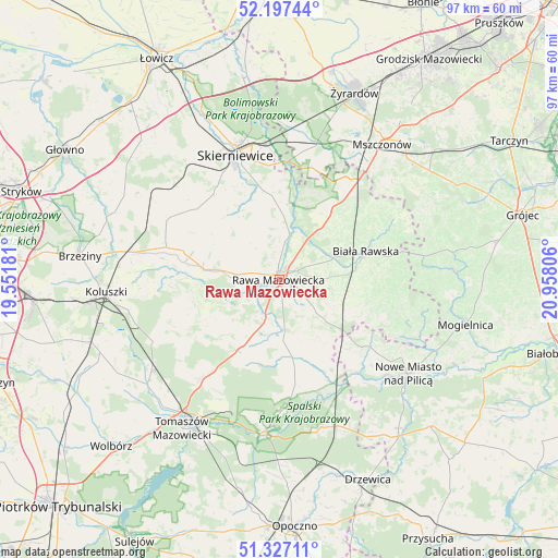
Rawa Mazowiecka GPS coordinates[2]
51° 45' 51.732" North, 20° 15' 17.748" East
| Map corner | latitude | longitude |
|---|---|---|
| Upper-left | 52.19744°, | 19.55181° |
| Center: | 51.76437°, | 20.25493° |
| Lower-right: | 51.32711°, | 20.95806° |
| Map W x H: | 96.8×96.8 km | = 60.1×60.1mi |
| max Lat: | 54.83135° ⇑38.7% North |
| Rawa Mazowiecka: | 51.76437° |
| min Lat: | ⇓61.3% South 49.21328° |
| min Long | Rawa Mazowiecka | max Long |
| 14.20249° | 20.25493° | 24.03723° |
| W 61.9%⇐ | ⇒38.1% E |
Elevation
Elevation of Rawa Mazowiecka is 138 m = 453 ft, and this is 53.4 m = 175 ft below average elevation for this country.
| Max E: |
974 m = 3196 ft | 63.4% |
| Avg. | 191.4 m = 628 ft | |
| Rawa Mazowiecka | 138 m = 453 ft | |
Min E: |
-3 m = -10 ft | 36.6% |
See also: Poland elevation on elevation.city.
Geographical zone
Rawa Mazowiecka is located in North temperate zone (between Tropic of Cancer and the Arctic Circle). Distance of this North polar circle is 1645.5 km =1022.5 mi to North.| Distance of | km | miles | from Rawa Mazowiecka |
|---|---|---|---|
| North Pole | 4251.4 | 2641.7 | to North |
| Arctic Circle | 1645.5 | 1022.5 | to North |
| Tropic Cancer | 3149.7 | 1957.1 | to South |
| Equator | 5755.7 | 3576.4 | to South |


Nearby cities:
15 places around Rawa Mazowiecka: (largest is in red/bold)
• Biała Rawska
15.7 km =9.8 mi,  72°
72°
• Cielądz
8.2 km =5.1 mi,  131°
131°
• Czerniewice
14 km =8.7 mi,  209°
209°
• Godzianów
21.1 km =13.1 mi,  314°
314°
• Głuchów
12.4 km =7.7 mi,  277°
277°
• Jeżów
20.4 km =12.7 mi,  285°
285°
• Kawęczyn Nowy
13.5 km =8.4 mi,  357°
357°
• Kowiesy
17.9 km =11.1 mi,  39°
39°
• Miedniewice
21.7 km =13.5 mi,  349°
349°
• Regnów
9.3 km =5.8 mi,  100°
100°
• Rzeczyca
18.7 km =11.6 mi,  171°
171°
• Sadkowice
18.4 km =11.4 mi, 103°
• Słupia
22 km =13.7 mi,  297°
297°
• Złota
6.7 km =4.2 mi, 277°
• Żelechlinek
16.2 km =10.1 mi,  249°
249°
Sources, notices
• [Note1] Compared only with cities in Poland existing in our database
• [Src1] Map data: © OpenStreetMap contributors (CC-BY-SA)
• [Src2] Other city data from geonames.org with taken over terms of usage.
• [Src3] Geographical zone / Annual Mean Temperature by Robert A. Rohde @ Wikipedia
