Drzewica geodata
Drzewica (Łódź Voivodeship) is a seat of a third-order administrative division; located in Poland in Europe/Warsaw (GMT+2) time zone. With population of 3,958 people, there are 825 cities with bigger population in this country. Compared to other cities in Poland, 55.5% of cities are located further ↓South; 64.7% of cities are located further ←West and 54.2% of cities have higher elevation than Drzewica. Note1


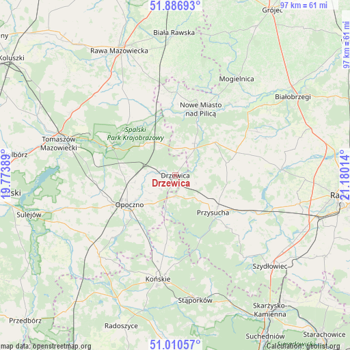
Drzewica GPS coordinates[2]
51° 27' 3.06" North, 20° 28' 37.236" East
| Map corner | latitude | longitude |
|---|---|---|
| Upper-left | 51.88693°, | 19.77389° |
| Center: | 51.45085°, | 20.47701° |
| Lower-right: | 51.01057°, | 21.18014° |
| Map W x H: | 97.4×97.4 km | = 60.5×60.5mi |
| max Lat: | 54.83135° ⇑44.5% North |
| Drzewica: | 51.45085° |
| min Lat: | ⇓55.5% South 49.21328° |
| min Long | Drzewica | max Long |
| 14.20249° | 20.47701° | 24.03723° |
| W 64.7%⇐ | ⇒35.3% E |
Elevation
Elevation of Drzewica is 161 m = 528 ft, and this is 30.4 m = 100 ft below average elevation for this country.
| Max E: |
974 m = 3196 ft | 54.2% |
| Avg. | 191.4 m = 628 ft | |
| Drzewica | 161 m = 528 ft | |
Min E: |
-3 m = -10 ft | 45.8% |
See also: Poland elevation on elevation.city.
Geographical zone
Drzewica is located in North temperate zone (between Tropic of Cancer and the Arctic Circle). Distance of this North polar circle is 1680.4 km =1044.2 mi to North.| Distance of | km | miles | from Drzewica |
|---|---|---|---|
| North Pole | 4286.3 | 2663.4 | to North |
| Arctic Circle | 1680.4 | 1044.2 | to North |
| Tropic Cancer | 3114.9 | 1935.5 | to South |
| Equator | 5720.8 | 3554.7 | to South |


Nearby cities:
15 places around Drzewica: (largest is in red/bold)
• Borkowice
20.4 km =12.7 mi,  135°
135°
• Bukowiec Opoczyński
15.1 km =9.4 mi,  255°
255°
• Gielniów
5.6 km =3.5 mi,  176°
176°
• Gowarczów
19.4 km =12.1 mi,  187°
187°
• Inowłódz
19.5 km =12.1 mi,  295°
295°
• Klwów
14.4 km =8.9 mi,  49°
49°
• Mroczków Gościnny
9.9 km =6.2 mi,  217°
217°
• Nowe Miasto nad Pilicą
19.8 km =12.3 mi,  20°
20°
• Odrzywół
9.4 km =5.8 mi,  35°
35°
• Opoczno
16.1 km =10 mi,  238°
238°
• Potworów
18.1 km =11.2 mi,  69°
69°
• Poświętne
11.9 km =7.4 mi,  319°
319°
• Przysucha
14.7 km =9.1 mi,  134°
134°
• Rusinów
7.8 km =4.8 mi,  101°
101°
• Wola Załężna
12.8 km =8 mi, 239°
Sources, notices
• [Note1] Compared only with cities in Poland existing in our database
• [Src1] Map data: © OpenStreetMap contributors (CC-BY-SA)
• [Src2] Other city data from geonames.org with taken over terms of usage.
• [Src3] Geographical zone / Annual Mean Temperature by Robert A. Rohde @ Wikipedia
