Kraśniczyn geodata
Kraśniczyn (Lublin) is a seat of a third-order administrative division; located in Poland in Europe/Warsaw (GMT+2) time zone. With population of 447 people, there are 3569 cities with bigger population in this country. Compared to other cities in Poland, 56.8% of cities are located further ↑North; 98.1% of cities are located further ←West and 59.4% of cities have lower elevation than Kraśniczyn. Note1


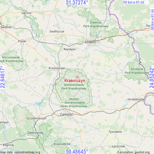
Kraśniczyn GPS coordinates[2]
50° 55' 54.156" North, 23° 20' 57.444" East
| Map corner | latitude | longitude |
|---|---|---|
| Upper-left | 51.37274°, | 22.64617° |
| Center: | 50.93171°, | 23.34929° |
| Lower-right: | 50.48645°, | 24.05242° |
| Map W x H: | 98.5×98.5 km | = 61.2×61.2mi |
| max Lat: | 54.83135° ⇑56.8% North |
| Kraśniczyn: | 50.93171° |
| min Lat: | ⇓43.2% South 49.21328° |
| min Long | Kraśniczyn | max Long |
| 14.20249° | 23.34929° | 24.03723° |
| W 98.1%⇐ | ⇒1.9% E |
Elevation
Elevation of Kraśniczyn is 199 m = 653 ft, and this is 7.6 m = 25 ft above average elevation for this country.
| Max E: |
974 m = 3196 ft | 40.6% |
| Kraśniczyn | 199 m 653 ft | |
| Avg. | 191.4 m = 628 ft | |
Min E: |
-3 m = -10 ft | 59.4% |
See also: Poland elevation on elevation.city.
Geographical zone
Kraśniczyn is located in North temperate zone (between Tropic of Cancer and the Arctic Circle). Distance of this North polar circle is 1738.1 km =1080 mi to North.| Distance of | km | miles | from Kraśniczyn |
|---|---|---|---|
| North Pole | 4344 | 2699.2 | to North |
| Arctic Circle | 1738.1 | 1080 | to North |
| Tropic Cancer | 3057.2 | 1899.7 | to South |
| Equator | 5663.1 | 3518.9 | to South |


Nearby cities:
15 places around Kraśniczyn: (largest is in red/bold)
• Dębowiec
14.9 km =9.3 mi,  184°
184°
• Grabowiec
18.7 km =11.6 mi,  131°
131°
• Izbica
14.7 km =9.1 mi,  250°
250°
• Krasne
14.5 km =9 mi,  238°
238°
• Krasnystaw
13.6 km =8.5 mi,  295°
295°
• Pokrówka
19.8 km =12.3 mi,  23°
23°
• Rejowiec
18.4 km =11.4 mi,  345°
345°
• Rejowiec Fabryczny
21.5 km =13.4 mi,  340°
340°
• Siennica Różana
8 km =5 mi, 346°
• Sitno
20.3 km =12.6 mi, 177°
• Skierbieszów
8.9 km =5.5 mi, 175°
• Stary Zamość
17.6 km =10.9 mi,  225°
225°
• Uchanie
21.3 km =13.2 mi,  96°
96°
• Wojsławice
13.9 km =8.6 mi, 95°
• Wysokie
21.7 km =13.5 mi,  204°
204°
Sources, notices
• [Note1] Compared only with cities in Poland existing in our database
• [Src1] Map data: © OpenStreetMap contributors (CC-BY-SA)
• [Src2] Other city data from geonames.org with taken over terms of usage.
• [Src3] Geographical zone / Annual Mean Temperature by Robert A. Rohde @ Wikipedia
