Chełm geodata
Chełm (Lublin) is a populated place; located in Poland in Europe/Warsaw (GMT+2) time zone. With population of 68,043 people, there are 72 cities with bigger population in this country. Compared to other cities in Poland, 50.9% of cities are located further ↑North; 98.7% of cities are located further ←West and 52% of cities have lower elevation than Chełm. Note1


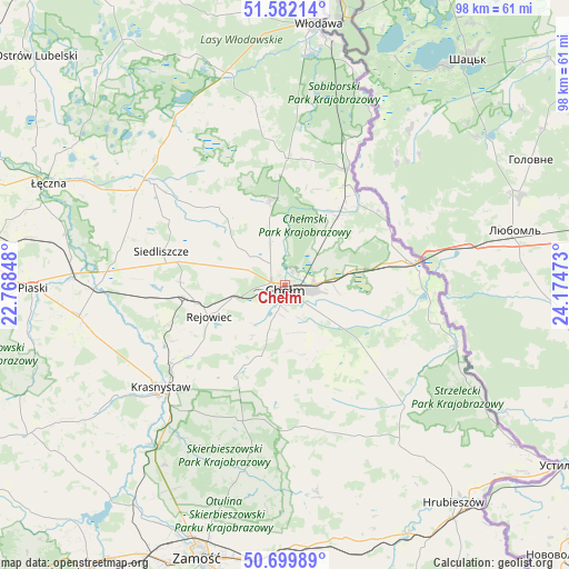
Chełm GPS coordinates[2]
51° 8' 35.232" North, 23° 28' 17.76" East
| Map corner | latitude | longitude |
|---|---|---|
| Upper-left | 51.58214°, | 22.76848° |
| Center: | 51.14312°, | 23.4716° |
| Lower-right: | 50.69989°, | 24.17473° |
| Map W x H: | 98.1×98.1 km | = 61×61mi |
| max Lat: | 54.83135° ⇑50.9% North |
| Chełm: | 51.14312° |
| min Lat: | ⇓49.1% South 49.21328° |
| min Long | Chełm | max Long |
| 14.20249° | 23.4716° | 24.03723° |
| W 98.7%⇐ | ⇒1.3% E |
Elevation
Elevation of Chełm is 177 m = 581 ft, and this is 14.4 m = 47 ft below average elevation for this country.
| Max E: |
974 m = 3196 ft | 48% |
| Avg. | 191.4 m = 628 ft | |
| Chełm | 177 m = 581 ft | |
Min E: |
-3 m = -10 ft | 52% |
See also: Chełm elevation on elevation.city.
Geographical zone
Chełm is located in North temperate zone (between Tropic of Cancer and the Arctic Circle). Distance of this North polar circle is 1714.6 km =1065.4 mi to North.| Distance of | km | miles | from Chełm |
|---|---|---|---|
| North Pole | 4320.5 | 2684.6 | to North |
| Arctic Circle | 1714.6 | 1065.4 | to North |
| Tropic Cancer | 3080.7 | 1914.3 | to South |
| Equator | 5686.6 | 3533.5 | to South |


Nearby cities:
15 places around Chełm: (largest is in red/bold)
• Dorohusk-Osada
22.6 km =14 mi,  82°
82°
• Kamień
9.5 km =5.9 mi,  123°
123°
• Krasne
19.7 km =12.2 mi,  266°
266°
• Pawłów
18.1 km =11.2 mi, 271°
• Pokrówka
5.4 km =3.4 mi,  186°
186°
• Rejowiec
14.4 km =8.9 mi,  246°
246°
• Rejowiec Fabryczny
16 km =9.9 mi,  258°
258°
• Ruda-Huta
13.5 km =8.4 mi,  39°
39°
• Sawin
14.8 km =9.2 mi,  349°
349°
• Siedliszcze
19.2 km =11.9 mi, 36°
• Siedliszcze
22.2 km =13.8 mi,  284°
284°
• Siennica Różana
18.9 km =11.7 mi,  213°
213°
• Wola Uhruska
22.6 km =14 mi,  28°
28°
• Świerże
20.1 km =12.5 mi,  65°
65°
• Żmudź
19.9 km =12.4 mi,  134°
134°
Sources, notices
• [Note1] Compared only with cities in Poland existing in our database
• [Src1] Map data: © OpenStreetMap contributors (CC-BY-SA)
• [Src2] Other city data from geonames.org with taken over terms of usage.
• [Src3] Geographical zone / Annual Mean Temperature by Robert A. Rohde @ Wikipedia
