Pokrówka geodata
Pokrówka (Lublin) is a populated place; located in Poland in Europe/Warsaw (GMT+2) time zone. With population of 1,594 people, there are 1780 cities with bigger population in this country. Compared to other cities in Poland, 52.7% of cities are located further ↑North; 98.7% of cities are located further ←West and 59.2% of cities have lower elevation than Pokrówka. Note1


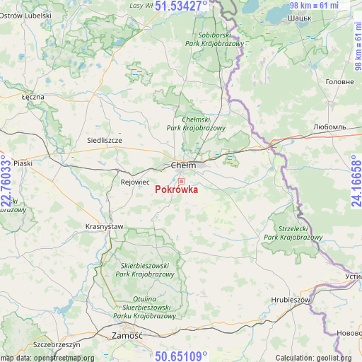
Pokrówka GPS coordinates[2]
51° 5' 41.244" North, 23° 27' 48.42" East
| Map corner | latitude | longitude |
|---|---|---|
| Upper-left | 51.53427°, | 22.76033° |
| Center: | 51.09479°, | 23.46345° |
| Lower-right: | 50.65109°, | 24.16658° |
| Map W x H: | 98.2×98.2 km | = 61×61mi |
| max Lat: | 54.83135° ⇑52.7% North |
| Pokrówka: | 51.09479° |
| min Lat: | ⇓47.3% South 49.21328° |
| min Long | Pokrówka | max Long |
| 14.20249° | 23.46345° | 24.03723° |
| W 98.7%⇐ | ⇒1.3% E |
Elevation
Elevation of Pokrówka is 198 m = 650 ft, and this is 6.6 m = 22 ft above average elevation for this country.
| Max E: |
974 m = 3196 ft | 40.8% |
| Pokrówka | 198 m 650 ft | |
| Avg. | 191.4 m = 628 ft | |
Min E: |
-3 m = -10 ft | 59.2% |
See also: Poland elevation on elevation.city.
Geographical zone
Pokrówka is located in North temperate zone (between Tropic of Cancer and the Arctic Circle). Distance of this North polar circle is 1720 km =1068.8 mi to North.| Distance of | km | miles | from Pokrówka |
|---|---|---|---|
| North Pole | 4325.9 | 2688 | to North |
| Arctic Circle | 1720 | 1068.8 | to North |
| Tropic Cancer | 3075.3 | 1910.9 | to South |
| Equator | 5681.2 | 3530.1 | to South |


Nearby cities:
15 places around Pokrówka: (largest is in red/bold)
• Białopole
22.3 km =13.9 mi,  122°
122°
• Chełm
5.4 km =3.4 mi,  6°
6°
• Kamień
8.5 km =5.3 mi,  88°
88°
• Krasne
19.5 km =12.1 mi,  282°
282°
• Krasnystaw
23.6 km =14.7 mi,  238°
238°
• Kraśniczyn
19.8 km =12.3 mi,  203°
203°
• Pawłów
18.5 km =11.5 mi,  288°
288°
• Rejowiec
12.7 km =7.9 mi,  268°
268°
• Rejowiec Fabryczny
15.2 km =9.4 mi, 278°
• Ruda-Huta
18.2 km =11.3 mi,  30°
30°
• Sawin
20.1 km =12.5 mi,  354°
354°
• Siennica Różana
14.3 km =8.9 mi,  223°
223°
• Wojsławice
20.4 km =12.7 mi,  163°
163°
• Świerże
23.3 km =14.5 mi,  54°
54°
• Żmudź
17.1 km =10.6 mi, 119°
Sources, notices
• [Note1] Compared only with cities in Poland existing in our database
• [Src1] Map data: © OpenStreetMap contributors (CC-BY-SA)
• [Src2] Other city data from geonames.org with taken over terms of usage.
• [Src3] Geographical zone / Annual Mean Temperature by Robert A. Rohde @ Wikipedia
