Racławice geodata
Racławice (Lesser Poland) is a populated place; located in Poland in Europe/Warsaw (GMT+2) time zone. With population of 510 people, there are 3513 cities with bigger population in this country. Compared to other cities in Poland, 71.4% of cities are located further ↑North; 61.6% of cities are located further ←West and 81% of cities have lower elevation than Racławice. Note1


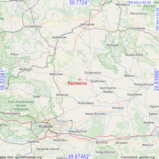
Racławice GPS coordinates[2]
50° 19' 32.268" North, 20° 14' 12.228" East
| Map corner | latitude | longitude |
|---|---|---|
| Upper-left | 50.7724°, | 19.53361° |
| Center: | 50.32563°, | 20.23673° |
| Lower-right: | 49.87462°, | 20.93986° |
| Map W x H: | 99.8×99.8 km | = 62×62mi |
| max Lat: | 54.83135° ⇑71.4% North |
| Racławice: | 50.32563° |
| min Lat: | ⇓28.6% South 49.21328° |
| min Long | Racławice | max Long |
| 14.20249° | 20.23673° | 24.03723° |
| W 61.6%⇐ | ⇒38.4% E |
Elevation
Elevation of Racławice is 270 m = 886 ft, and this is 78.6 m = 258 ft above average elevation for this country.
| Max E: |
974 m = 3196 ft | 19% |
| Racławice | 270 m 886 ft | |
| Avg. | 191.4 m = 628 ft | |
Min E: |
-3 m = -10 ft | 81% |
See also: Poland elevation on elevation.city.
Geographical zone
Racławice is located in North temperate zone (between Tropic of Cancer and the Arctic Circle). Distance of this North polar circle is 1805.5 km =1121.9 mi to North.| Distance of | km | miles | from Racławice |
|---|---|---|---|
| North Pole | 4411.4 | 2741.1 | to North |
| Arctic Circle | 1805.5 | 1121.9 | to North |
| Tropic Cancer | 2989.8 | 1857.8 | to South |
| Equator | 5595.7 | 3477 | to South |


Nearby cities:
15 places around Racławice: (largest is in red/bold)
• Czarnocin
19.9 km =12.4 mi,  85°
85°
• Działoszyce
9.3 km =5.8 mi,  61°
61°
• Kazimierza Wielka
19.4 km =12.1 mi,  110°
110°
• Klimontów
12.3 km =7.6 mi,  151°
151°
• Kościelec
17.7 km =11 mi,  141°
141°
• Książ Wielki
14.8 km =9.2 mi,  332°
332°
• Miechów
15.2 km =9.4 mi,  283°
283°
• Miechów Charsznica
21.8 km =13.5 mi,  291°
291°
• Miłocice
17.2 km =10.7 mi,  233°
233°
• Niedźwiedź
15.2 km =9.4 mi,  222°
222°
• Pałecznica
6.2 km =3.9 mi,  130°
130°
• Proszowice
15.2 km =9.4 mi,  165°
165°
• Sieciechowice
20.8 km =12.9 mi,  244°
244°
• Skalbmierz
11.6 km =7.2 mi, 93°
• Słomniki
14.5 km =9 mi, 229°
Sources, notices
• [Note1] Compared only with cities in Poland existing in our database
• [Src1] Map data: © OpenStreetMap contributors (CC-BY-SA)
• [Src2] Other city data from geonames.org with taken over terms of usage.
• [Src3] Geographical zone / Annual Mean Temperature by Robert A. Rohde @ Wikipedia
