Słomniki geodata
Słomniki (Lesser Poland) is a seat of a third-order administrative division; located in Poland in Europe/Warsaw (GMT+2) time zone. With population of 4,340 people, there are 762 cities with bigger population in this country. Compared to other cities in Poland, 73.4% of cities are located further ↑North; 59.5% of cities are located further ←West and 76.3% of cities have lower elevation than Słomniki. Note1


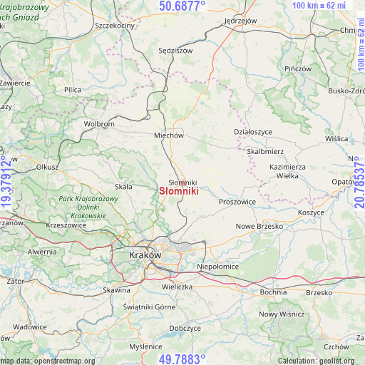
Słomniki GPS coordinates[2]
50° 14' 24.432" North, 20° 4' 56.064" East
| Map corner | latitude | longitude |
|---|---|---|
| Upper-left | 50.6877°, | 19.37912° |
| Center: | 50.24012°, | 20.08224° |
| Lower-right: | 49.7883°, | 20.78537° |
| Map W x H: | 100×100 km | = 62.1×62.1mi |
| max Lat: | 54.83135° ⇑73.4% North |
| Słomniki: | 50.24012° |
| min Lat: | ⇓26.6% South 49.21328° |
| min Long | Słomniki | max Long |
| 14.20249° | 20.08224° | 24.03723° |
| W 59.5%⇐ | ⇒40.5% E |
Elevation
Elevation of Słomniki is 251 m = 823 ft, and this is 59.6 m = 196 ft above average elevation for this country.
| Max E: |
974 m = 3196 ft | 23.7% |
| Słomniki | 251 m 823 ft | |
| Avg. | 191.4 m = 628 ft | |
Min E: |
-3 m = -10 ft | 76.3% |
See also: Poland elevation on elevation.city.
Geographical zone
Słomniki is located in North temperate zone (between Tropic of Cancer and the Arctic Circle). Distance of this North polar circle is 1815 km =1127.8 mi to North.| Distance of | km | miles | from Słomniki |
|---|---|---|---|
| North Pole | 4420.9 | 2747 | to North |
| Arctic Circle | 1815 | 1127.8 | to North |
| Tropic Cancer | 2980.3 | 1851.9 | to South |
| Equator | 5586.2 | 3471.1 | to South |


Nearby cities:
15 places around Słomniki: (largest is in red/bold)
• Baranówka
10.7 km =6.6 mi,  172°
172°
• Dojazdów
13.3 km =8.3 mi, 170°
• Iwanowice
8.7 km =5.4 mi,  259°
259°
• Kocmyrzów
12.8 km =8 mi,  163°
163°
• Luborzyca
11.8 km =7.3 mi, 168°
• Masłomiąca
10.5 km =6.5 mi,  213°
213°
• Michałowice
11.6 km =7.2 mi,  218°
218°
• Miechów
13.5 km =8.4 mi,  343°
343°
• Miłocice
2.9 km =1.8 mi,  254°
254°
• Niedźwiedź
2 km =1.2 mi, 155°
• Pałecznica
16.6 km =10.3 mi,  70°
70°
• Proszowice
15.6 km =9.7 mi,  109°
109°
• Racławice
14.5 km =9 mi,  49°
49°
• Sieciechowice
7.8 km =4.8 mi,  273°
273°
• Skała
16.3 km =10.1 mi, 266°
Sources, notices
• [Note1] Compared only with cities in Poland existing in our database
• [Src1] Map data: © OpenStreetMap contributors (CC-BY-SA)
• [Src2] Other city data from geonames.org with taken over terms of usage.
• [Src3] Geographical zone / Annual Mean Temperature by Robert A. Rohde @ Wikipedia
