Proszowice geodata
Proszowice (Lesser Poland) is a seat of a second-order administrative division; located in Poland in Europe/Warsaw (GMT+2) time zone. With population of 6,146 people, there are 591 cities with bigger population in this country. Compared to other cities in Poland, 74.7% of cities are located further ↑North; 62.3% of cities are located further ←West and 67.7% of cities have lower elevation than Proszowice. Note1


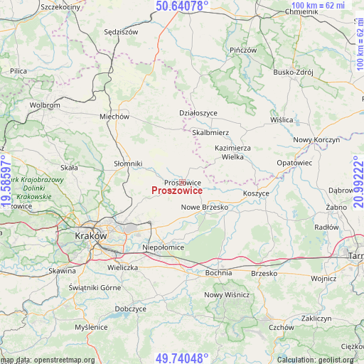
Proszowice GPS coordinates[2]
50° 11' 33.9" North, 20° 17' 20.724" East
| Map corner | latitude | longitude |
|---|---|---|
| Upper-left | 50.64078°, | 19.58597° |
| Center: | 50.19275°, | 20.28909° |
| Lower-right: | 49.74048°, | 20.99222° |
| Map W x H: | 100.1×100.1 km | = 62.2×62.2mi |
| max Lat: | 54.83135° ⇑74.7% North |
| Proszowice: | 50.19275° |
| min Lat: | ⇓25.3% South 49.21328° |
| min Long | Proszowice | max Long |
| 14.20249° | 20.28909° | 24.03723° |
| W 62.3%⇐ | ⇒37.7% E |
Elevation
Elevation of Proszowice is 222 m = 728 ft, and this is 30.6 m = 100 ft above average elevation for this country.
| Max E: |
974 m = 3196 ft | 32.3% |
| Proszowice | 222 m 728 ft | |
| Avg. | 191.4 m = 628 ft | |
Min E: |
-3 m = -10 ft | 67.7% |
See also: Poland elevation on elevation.city.
Geographical zone
Proszowice is located in North temperate zone (between Tropic of Cancer and the Arctic Circle). Distance of this North polar circle is 1820.3 km =1131.1 mi to North.| Distance of | km | miles | from Proszowice |
|---|---|---|---|
| North Pole | 4426.2 | 2750.3 | to North |
| Arctic Circle | 1820.3 | 1131.1 | to North |
| Tropic Cancer | 2975 | 1848.6 | to South |
| Equator | 5580.9 | 3467.8 | to South |


Nearby cities:
15 places around Proszowice: (largest is in red/bold)
• Baranówka
14.3 km =8.9 mi,  247°
247°
• Dojazdów
14.8 km =9.2 mi,  238°
238°
• Drwinia
15.2 km =9.4 mi,  134°
134°
• Grobla
12.3 km =7.6 mi, 127°
• Klimontów
4.5 km =2.8 mi,  28°
28°
• Kocmyrzów
13.2 km =8.2 mi, 237°
• Kościelec
7.3 km =4.5 mi,  83°
83°
• Luborzyca
14 km =8.7 mi, 243°
• Niedźwiedź
14.3 km =8.9 mi,  284°
284°
• Nowe Brzesko
9.2 km =5.7 mi,  137°
137°
• Pałecznica
10.9 km =6.8 mi,  5°
5°
• Racławice
15.2 km =9.4 mi,  345°
345°
• Wawrzeńczyce
9.4 km =5.8 mi,  168°
168°
• Wola Zabierzowska
13.7 km =8.5 mi, 167°
• Zabierzów Bocheński
14 km =8.7 mi, 171°
Sources, notices
• [Note1] Compared only with cities in Poland existing in our database
• [Src1] Map data: © OpenStreetMap contributors (CC-BY-SA)
• [Src2] Other city data from geonames.org with taken over terms of usage.
• [Src3] Geographical zone / Annual Mean Temperature by Robert A. Rohde @ Wikipedia
