Kazimierza Wielka geodata
Kazimierza Wielka (Świętokrzyskie) is a seat of a second-order administrative division; located in Poland in Europe/Warsaw (GMT+2) time zone. With population of 5,696 people, there are 629 cities with bigger population in this country. Compared to other cities in Poland, 72.8% of cities are located further ↑North; 65.1% of cities are located further ←West and 56.5% of cities have lower elevation than Kazimierza Wielka. Note1
Administrative division(s):
- Level 1: Świętokrzyskie
- Level 2: Powiat kazimierski
- Level 3: Kazimierza Wielka


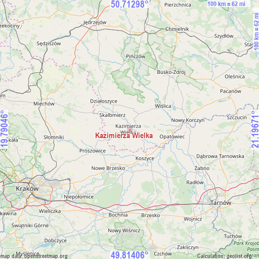
Kazimierza Wielka GPS coordinates[2]
50° 15' 56.304" North, 20° 29' 36.888" East
| Map corner | latitude | longitude |
|---|---|---|
| Upper-left | 50.71298°, | 19.79046° |
| Center: | 50.26564°, | 20.49358° |
| Lower-right: | 49.81406°, | 21.19671° |
| Map W x H: | 100×99.9 km | = 62.1×62.1mi |
| max Lat: | 54.83135° ⇑72.8% North |
| Kazimierza Wielka: | 50.26564° |
| min Lat: | ⇓27.2% South 49.21328° |
| min Long | Kazimierza Wiel | max Long |
| 14.20249° | 20.49358° | 24.03723° |
| W 65.1%⇐ | ⇒34.9% E |
Elevation
Elevation of Kazimierza Wielka is 189 m = 620 ft, and this is 2.4 m = 8 ft below average elevation for this country.
| Max E: |
974 m = 3196 ft | 43.5% |
| Avg. | 191.4 m = 628 ft | |
| Kazimierza Wielka | 189 m = 620 ft | |
Min E: |
-3 m = -10 ft | 56.5% |
See also: Poland elevation on elevation.city.
Geographical zone
Kazimierza Wielka is located in North temperate zone (between Tropic of Cancer and the Arctic Circle). Distance of this North polar circle is 1812.2 km =1126 mi to North.| Distance of | km | miles | from Kazimierza Wielka |
|---|---|---|---|
| North Pole | 4418 | 2745.2 | to North |
| Arctic Circle | 1812.2 | 1126 | to North |
| Tropic Cancer | 2983.1 | 1853.6 | to South |
| Equator | 5589 | 3472.8 | to South |


Nearby cities:
15 places around Kazimierza Wielka: (largest is in red/bold)
• Bejsce
8 km =5 mi,  111°
111°
• Czarnocin
8.5 km =5.3 mi,  10°
10°
• Działoszyce
15 km =9.3 mi,  317°
317°
• Grobla
16.3 km =10.1 mi,  197°
197°
• Klimontów
13 km =8.1 mi,  251°
251°
• Koszyce
12.2 km =7.6 mi,  150°
150°
• Kościelec
10.3 km =6.4 mi,  225°
225°
• Nowe Brzesko
17 km =10.6 mi,  209°
209°
• Opatowiec
16.5 km =10.3 mi,  98°
98°
• Pałecznica
13.8 km =8.6 mi,  281°
281°
• Proszowice
16.7 km =10.4 mi,  240°
240°
• Skalbmierz
9 km =5.6 mi,  312°
312°
• Uście Solne
16.4 km =10.2 mi,  174°
174°
• Wiślica
15.8 km =9.8 mi,  54°
54°
• Złota
14.7 km =9.1 mi,  28°
28°
Sources, notices
• [Note1] Compared only with cities in Poland existing in our database
• [Src1] Map data: © OpenStreetMap contributors (CC-BY-SA)
• [Src2] Other city data from geonames.org with taken over terms of usage.
• [Src3] Geographical zone / Annual Mean Temperature by Robert A. Rohde @ Wikipedia
