Miechów geodata
Miechów (Lesser Poland) is a seat of a second-order administrative division; located in Poland in Europe/Warsaw (GMT+2) time zone. With population of 11,735 people, there are 404 cities with bigger population in this country. Compared to other cities in Poland, 70.6% of cities are located further ↑North; 58.8% of cities are located further ←West and 86.4% of cities have lower elevation than Miechów. Note1
Administrative division(s):
- Level 1: Lesser Poland
- Level 2: Powiat miechowski
- Level 3: Gmina Miechów


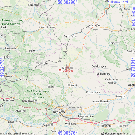
Miechów GPS coordinates[2]
50° 21' 23.328" North, 20° 1' 40.368" East
| Map corner | latitude | longitude |
|---|---|---|
| Upper-left | 50.80296°, | 19.32476° |
| Center: | 50.35648°, | 20.02788° |
| Lower-right: | 49.90576°, | 20.73101° |
| Map W x H: | 99.8×99.8 km | = 62×62mi |
| max Lat: | 54.83135° ⇑70.6% North |
| Miechów: | 50.35648° |
| min Lat: | ⇓29.4% South 49.21328° |
| min Long | Miechów | max Long |
| 14.20249° | 20.02788° | 24.03723° |
| W 58.8%⇐ | ⇒41.2% E |
Elevation
Elevation of Miechów is 298 m = 978 ft, and this is 106.6 m = 350 ft above average elevation for this country.
| Max E: |
974 m = 3196 ft | 13.6% |
| Miechów | 298 m 978 ft | |
| Avg. | 191.4 m = 628 ft | |
Min E: |
-3 m = -10 ft | 86.4% |
See also: Poland elevation on elevation.city.
Geographical zone
Miechów is located in North temperate zone (between Tropic of Cancer and the Arctic Circle). Distance of this North polar circle is 1802.1 km =1119.8 mi to North.| Distance of | km | miles | from Miechów |
|---|---|---|---|
| North Pole | 4407.9 | 2738.9 | to North |
| Arctic Circle | 1802.1 | 1119.8 | to North |
| Tropic Cancer | 2993.2 | 1859.9 | to South |
| Equator | 5599.1 | 3479.1 | to South |


Nearby cities:
15 places around Miechów: (largest is in red/bold)
• Iwanowice
15.2 km =9.4 mi,  198°
198°
• Kozłów
14.2 km =8.8 mi,  359°
359°
• Książ Wielki
12.5 km =7.8 mi,  39°
39°
• Kępie
13.1 km =8.1 mi,  330°
330°
• Marcinowice
16.4 km =10.2 mi,  352°
352°
• Miechów Charsznica
7 km =4.3 mi,  308°
308°
• Miłocice
13.7 km =8.5 mi,  175°
175°
• Niedźwiedź
15.4 km =9.6 mi,  162°
162°
• Poręba Górna
16.8 km =10.4 mi,  269°
269°
• Racławice
15.2 km =9.4 mi,  103°
103°
• Sieciechowice
13.1 km =8.1 mi, 197°
• Skała
18.7 km =11.6 mi,  221°
221°
• Słomniki
13.5 km =8.4 mi, 163°
• Wierzchowisko
15.2 km =9.4 mi,  277°
277°
• Żarnowiec
18 km =11.2 mi,  319°
319°
Sources, notices
• [Note1] Compared only with cities in Poland existing in our database
• [Src1] Map data: © OpenStreetMap contributors (CC-BY-SA)
• [Src2] Other city data from geonames.org with taken over terms of usage.
• [Src3] Geographical zone / Annual Mean Temperature by Robert A. Rohde @ Wikipedia
