Grobla geodata
Grobla (Lesser Poland) is a populated place; located in Poland in Europe/Warsaw (GMT+2) time zone. With population of 970 people, there are 2550 cities with bigger population in this country. Compared to other cities in Poland, 77% of cities are located further ↑North; 64% of cities are located further ←West and 53.8% of cities have lower elevation than Grobla. Note1


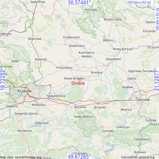
Grobla GPS coordinates[2]
50° 7' 32.7" North, 20° 25' 32.304" East
| Map corner | latitude | longitude |
|---|---|---|
| Upper-left | 50.57441°, | 19.72252° |
| Center: | 50.12575°, | 20.42564° |
| Lower-right: | 49.67285°, | 21.12877° |
| Map W x H: | 100.2×100.2 km | = 62.3×62.3mi |
| max Lat: | 54.83135° ⇑77% North |
| Grobla: | 50.12575° |
| min Lat: | ⇓23% South 49.21328° |
| min Long | Grobla | max Long |
| 14.20249° | 20.42564° | 24.03723° |
| W 64%⇐ | ⇒36% E |
Elevation
Elevation of Grobla is 182 m = 597 ft, and this is 9.4 m = 31 ft below average elevation for this country.
| Max E: |
974 m = 3196 ft | 46.2% |
| Avg. | 191.4 m = 628 ft | |
| Grobla | 182 m = 597 ft | |
Min E: |
-3 m = -10 ft | 53.8% |
See also: Poland elevation on elevation.city.
Geographical zone
Grobla is located in North temperate zone (between Tropic of Cancer and the Arctic Circle). Distance of this North polar circle is 1827.7 km =1135.7 mi to North.| Distance of | km | miles | from Grobla |
|---|---|---|---|
| North Pole | 4433.6 | 2754.9 | to North |
| Arctic Circle | 1827.7 | 1135.7 | to North |
| Tropic Cancer | 2967.5 | 1843.9 | to South |
| Equator | 5573.5 | 3463.2 | to South |


Nearby cities:
15 places around Grobla: (largest is in red/bold)
• Baczków
10.3 km =6.4 mi,  173°
173°
• Borek
14.2 km =8.8 mi,  147°
147°
• Drwinia
3.3 km =2.1 mi,  159°
159°
• Dziewin
6 km =3.7 mi, 159°
• Klimontów
13.7 km =8.5 mi,  326°
326°
• Koszyce
12 km =7.5 mi,  65°
65°
• Kościelec
8.7 km =5.4 mi,  343°
343°
• Nowe Brzesko
3.6 km =2.2 mi,  281°
281°
• Proszowice
12.3 km =7.6 mi,  307°
307°
• Strzelce Wielkie
11.6 km =7.2 mi,  107°
107°
• Uście Solne
6.4 km =4 mi,  96°
96°
• Wawrzeńczyce
8 km =5 mi,  257°
257°
• Wola Batorska
14 km =8.7 mi,  234°
234°
• Wola Zabierzowska
8.9 km =5.5 mi, 228°
• Zabierzów Bocheński
9.9 km =6.2 mi, 229°
Sources, notices
• [Note1] Compared only with cities in Poland existing in our database
• [Src1] Map data: © OpenStreetMap contributors (CC-BY-SA)
• [Src2] Other city data from geonames.org with taken over terms of usage.
• [Src3] Geographical zone / Annual Mean Temperature by Robert A. Rohde @ Wikipedia
