Drwinia geodata
Drwinia (Lesser Poland) is a populated place; located in Poland in Europe/Warsaw (GMT+2) time zone. With population of 600 people, there are 3270 cities with bigger population in this country. Compared to other cities in Poland, 78% of cities are located further ↑North; 64.3% of cities are located further ←West and 53.8% of cities have lower elevation than Drwinia. Note1


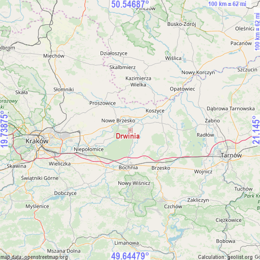
Drwinia GPS coordinates[2]
50° 5' 52.62" North, 20° 26' 30.732" East
| Map corner | latitude | longitude |
|---|---|---|
| Upper-left | 50.54687°, | 19.73875° |
| Center: | 50.09795°, | 20.44187° |
| Lower-right: | 49.64479°, | 21.145° |
| Map W x H: | 100.3×100.3 km | = 62.3×62.3mi |
| max Lat: | 54.83135° ⇑78% North |
| Drwinia: | 50.09795° |
| min Lat: | ⇓22% South 49.21328° |
| min Long | Drwinia | max Long |
| 14.20249° | 20.44187° | 24.03723° |
| W 64.3%⇐ | ⇒35.7% E |
Elevation
Elevation of Drwinia is 182 m = 597 ft, and this is 9.4 m = 31 ft below average elevation for this country.
| Max E: |
974 m = 3196 ft | 46.2% |
| Avg. | 191.4 m = 628 ft | |
| Drwinia | 182 m = 597 ft | |
Min E: |
-3 m = -10 ft | 53.8% |
See also: Poland elevation on elevation.city.
Geographical zone
Drwinia is located in North temperate zone (between Tropic of Cancer and the Arctic Circle). Distance of this North polar circle is 1830.8 km =1137.6 mi to North.| Distance of | km | miles | from Drwinia |
|---|---|---|---|
| North Pole | 4436.7 | 2756.8 | to North |
| Arctic Circle | 1830.8 | 1137.6 | to North |
| Tropic Cancer | 2964.5 | 1842.1 | to South |
| Equator | 5570.4 | 3461.3 | to South |


Nearby cities:
15 places around Drwinia: (largest is in red/bold)
• Baczków
7.1 km =4.4 mi,  180°
180°
• Borek
10.9 km =6.8 mi,  144°
144°
• Damienice
12.2 km =7.6 mi,  195°
195°
• Dziewin
2.7 km =1.7 mi,  159°
159°
• Grobla
3.3 km =2.1 mi,  339°
339°
• Koszyce
12.6 km =7.8 mi,  50°
50°
• Kościelec
12 km =7.5 mi, 342°
• Krzeczów
12.6 km =7.8 mi, 164°
• Nowe Brzesko
6 km =3.7 mi,  309°
309°
• Rzezawa
13.1 km =8.1 mi, 156°
• Strzelce Wielkie
9.9 km =6.2 mi,  92°
92°
• Uście Solne
5.7 km =3.5 mi,  65°
65°
• Wawrzeńczyce
9.1 km =5.7 mi,  278°
278°
• Wola Zabierzowska
8.3 km =5.2 mi,  250°
250°
• Zabierzów Bocheński
9.4 km =5.8 mi, 249°
Sources, notices
• [Note1] Compared only with cities in Poland existing in our database
• [Src1] Map data: © OpenStreetMap contributors (CC-BY-SA)
• [Src2] Other city data from geonames.org with taken over terms of usage.
• [Src3] Geographical zone / Annual Mean Temperature by Robert A. Rohde @ Wikipedia
