Słupiec geodata
Słupiec (Lesser Poland) is a populated place; located in Poland in Europe/Warsaw (GMT+2) time zone. With population of 1,118 people, there are 2282 cities with bigger population in this country. Compared to other cities in Poland, 71.3% of cities are located further ↑North; 75.7% of cities are located further ←West and 54.9% of cities have higher elevation than Słupiec. Note1


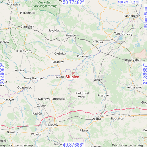
Słupiec GPS coordinates[2]
50° 19' 40.332" North, 21° 11' 37.464" East
| Map corner | latitude | longitude |
|---|---|---|
| Upper-left | 50.77462°, | 20.49062° |
| Center: | 50.32787°, | 21.19374° |
| Lower-right: | 49.87688°, | 21.89687° |
| Map W x H: | 99.8×99.8 km | = 62×62mi |
| max Lat: | 54.83135° ⇑71.3% North |
| Słupiec: | 50.32787° |
| min Lat: | ⇓28.7% South 49.21328° |
| min Long | Słupiec | max Long |
| 14.20249° | 21.19374° | 24.03723° |
| W 75.7%⇐ | ⇒24.3% E |
Elevation
Elevation of Słupiec is 159 m = 522 ft, and this is 32.4 m = 106 ft below average elevation for this country.
| Max E: |
974 m = 3196 ft | 54.9% |
| Avg. | 191.4 m = 628 ft | |
| Słupiec | 159 m = 522 ft | |
Min E: |
-3 m = -10 ft | 45.1% |
See also: Poland elevation on elevation.city.
Geographical zone
Słupiec is located in North temperate zone (between Tropic of Cancer and the Arctic Circle). Distance of this North polar circle is 1805.2 km =1121.7 mi to North.| Distance of | km | miles | from Słupiec |
|---|---|---|---|
| North Pole | 4411.1 | 2740.9 | to North |
| Arctic Circle | 1805.2 | 1121.7 | to North |
| Tropic Cancer | 2990 | 1857.9 | to South |
| Equator | 5595.9 | 3477.1 | to South |


Nearby cities:
15 places around Słupiec: (largest is in red/bold)
• Borowa
12.9 km =8 mi,  60°
60°
• Czermin
10 km =6.2 mi,  82°
82°
• Gawłuszowice
16.5 km =10.3 mi,  54°
54°
• Mielec
17 km =10.6 mi,  105°
105°
• Oleśnica
16.7 km =10.4 mi,  326°
326°
• Pacanów
13.5 km =8.4 mi,  306°
306°
• Połaniec
13.3 km =8.3 mi,  27°
27°
• Radgoszcz
14.7 km =9.1 mi,  202°
202°
• Radomyśl Wielki
15.7 km =9.8 mi,  157°
157°
• Smęgorzów
17.4 km =10.8 mi,  230°
230°
• Szczucin
8.7 km =5.4 mi,  256°
256°
• Słupia
12.5 km =7.8 mi,  299°
299°
• Trzciana
10.4 km =6.5 mi,  102°
102°
• Wadowice Górne
10.5 km =6.5 mi,  133°
133°
• Łubnice
9.8 km =6.1 mi,  341°
341°
Sources, notices
• [Note1] Compared only with cities in Poland existing in our database
• [Src1] Map data: © OpenStreetMap contributors (CC-BY-SA)
• [Src2] Other city data from geonames.org with taken over terms of usage.
• [Src3] Geographical zone / Annual Mean Temperature by Robert A. Rohde @ Wikipedia
