Pacanów geodata
Pacanów (Świętokrzyskie) is a seat of a third-order administrative division; located in Poland in Europe/Warsaw (GMT+2) time zone. With population of 1,137 people, there are 2266 cities with bigger population in this country. Compared to other cities in Poland, 69.4% of cities are located further ↑North; 73.3% of cities are located further ←West and 56.8% of cities have lower elevation than Pacanów. Note1


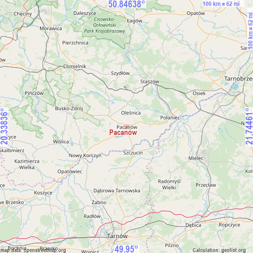
Pacanów GPS coordinates[2]
50° 24' 1.116" North, 21° 2' 29.328" East
| Map corner | latitude | longitude |
|---|---|---|
| Upper-left | 50.84638°, | 20.33836° |
| Center: | 50.40031°, | 21.04148° |
| Lower-right: | 49.95°, | 21.74461° |
| Map W x H: | 99.7×99.7 km | = 62×62mi |
| max Lat: | 54.83135° ⇑69.4% North |
| Pacanów: | 50.40031° |
| min Lat: | ⇓30.6% South 49.21328° |
| min Long | Pacanów | max Long |
| 14.20249° | 21.04148° | 24.03723° |
| W 73.3%⇐ | ⇒26.7% E |
Elevation
Elevation of Pacanów is 190 m = 623 ft, and this is 1.4 m = 5 ft below average elevation for this country.
| Max E: |
974 m = 3196 ft | 43.2% |
| Avg. | 191.4 m = 628 ft | |
| Pacanów | 190 m = 623 ft | |
Min E: |
-3 m = -10 ft | 56.8% |
See also: Poland elevation on elevation.city.
Geographical zone
Pacanów is located in North temperate zone (between Tropic of Cancer and the Arctic Circle). Distance of this North polar circle is 1797.2 km =1116.7 mi to North.| Distance of | km | miles | from Pacanów |
|---|---|---|---|
| North Pole | 4403.1 | 2736 | to North |
| Arctic Circle | 1797.2 | 1116.7 | to North |
| Tropic Cancer | 2998.1 | 1862.9 | to South |
| Equator | 5604 | 3482.2 | to South |


Nearby cities:
15 places around Pacanów: (largest is in red/bold)
• Bolesław
17.3 km =10.7 mi,  215°
215°
• Mędrzechów
14.7 km =9.1 mi,  206°
206°
• Nowy Korczyn
19.9 km =12.4 mi,  236°
236°
• Oleśnica
6.1 km =3.8 mi,  15°
15°
• Połaniec
17.4 km =10.8 mi,  77°
77°
• Rytwiany
18.5 km =11.5 mi,  39°
39°
• Smęgorzów
19.3 km =12 mi,  187°
187°
• Solec-Zdrój
11.4 km =7.1 mi,  250°
250°
• Stopnica
8.6 km =5.3 mi,  301°
301°
• Szczucin
10.4 km =6.5 mi,  166°
166°
• Słupia
1.9 km =1.2 mi,  183°
183°
• Słupiec
13.5 km =8.4 mi,  126°
126°
• Tuczępy
13.4 km =8.3 mi,  344°
344°
• Widuchowa
20 km =12.4 mi, 300°
• Łubnice
7.8 km =4.8 mi, 80°
Sources, notices
• [Note1] Compared only with cities in Poland existing in our database
• [Src1] Map data: © OpenStreetMap contributors (CC-BY-SA)
• [Src2] Other city data from geonames.org with taken over terms of usage.
• [Src3] Geographical zone / Annual Mean Temperature by Robert A. Rohde @ Wikipedia
