Staszów geodata
Staszów (Świętokrzyskie) is a seat of a second-order administrative division; located in Poland in Europe/Warsaw (GMT+2) time zone. With population of 16,137 people, there are 309 cities with bigger population in this country. Compared to other cities in Poland, 66.1% of cities are located further ↑North; 75.4% of cities are located further ←West and 58.5% of cities have lower elevation than Staszów. Note1


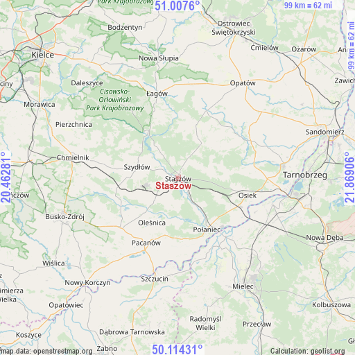
Staszów GPS coordinates[2]
50° 33' 47.052" North, 21° 9' 57.348" East
| Map corner | latitude | longitude |
|---|---|---|
| Upper-left | 51.0076°, | 20.46281° |
| Center: | 50.56307°, | 21.16593° |
| Lower-right: | 50.11431°, | 21.86906° |
| Map W x H: | 99.3×99.3 km | = 61.7×61.7mi |
| max Lat: | 54.83135° ⇑66.1% North |
| Staszów: | 50.56307° |
| min Lat: | ⇓33.9% South 49.21328° |
| min Long | Staszów | max Long |
| 14.20249° | 21.16593° | 24.03723° |
| W 75.4%⇐ | ⇒24.6% E |
Elevation
Elevation of Staszów is 195 m = 640 ft, and this is 3.6 m = 12 ft above average elevation for this country.
| Max E: |
974 m = 3196 ft | 41.5% |
| Staszów | 195 m 640 ft | |
| Avg. | 191.4 m = 628 ft | |
Min E: |
-3 m = -10 ft | 58.5% |
See also: Poland elevation on elevation.city.
Geographical zone
Staszów is located in North temperate zone (between Tropic of Cancer and the Arctic Circle). Distance of this North polar circle is 1779.1 km =1105.5 mi to North.| Distance of | km | miles | from Staszów |
|---|---|---|---|
| North Pole | 4385 | 2724.7 | to North |
| Arctic Circle | 1779.1 | 1105.5 | to North |
| Tropic Cancer | 3016.2 | 1874.2 | to South |
| Equator | 5622.1 | 3493.4 | to South |


Nearby cities:
15 places around Staszów: (largest is in red/bold)
• Bogoria
11.9 km =7.4 mi,  33°
33°
• Gawłuszowice
22.6 km =14 mi,  137°
137°
• Iwaniska
20.4 km =12.7 mi,  23°
23°
• Oleśnica
14.1 km =8.8 mi,  210°
210°
• Osiek
20.1 km =12.5 mi,  103°
103°
• Pacanów
20.1 km =12.5 mi, 205°
• Połaniec
16.6 km =10.3 mi,  150°
150°
• Raków
15 km =9.3 mi,  325°
325°
• Rytwiany
4.7 km =2.9 mi, 142°
• Stopnica
21.1 km =13.1 mi,  229°
229°
• Szydłów
11.7 km =7.3 mi,  285°
285°
• Słupia
21.9 km =13.6 mi,  204°
204°
• Tuczępy
13.3 km =8.3 mi,  247°
247°
• Wiśniowa
6.9 km =4.3 mi,  60°
60°
• Łubnice
16.9 km =10.5 mi,  183°
183°
Sources, notices
• [Note1] Compared only with cities in Poland existing in our database
• [Src1] Map data: © OpenStreetMap contributors (CC-BY-SA)
• [Src2] Other city data from geonames.org with taken over terms of usage.
• [Src3] Geographical zone / Annual Mean Temperature by Robert A. Rohde @ Wikipedia
