Tarnowiec geodata
Tarnowiec (Lesser Poland) is a populated place; located in Poland in Europe/Warsaw (GMT+2) time zone. With population of 1,485 people, there are 1888 cities with bigger population in this country. Compared to other cities in Poland, 83.7% of cities are located further ↑North; 72.4% of cities are located further ←West and 71.6% of cities have lower elevation than Tarnowiec. Note1


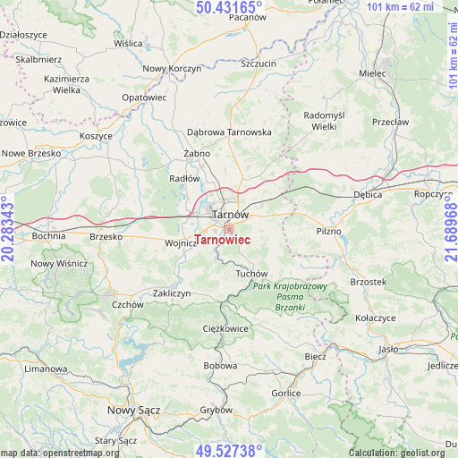
Tarnowiec GPS coordinates[2]
49° 58' 53.904" North, 20° 59' 11.58" East
| Map corner | latitude | longitude |
|---|---|---|
| Upper-left | 50.43165°, | 20.28343° |
| Center: | 49.98164°, | 20.98655° |
| Lower-right: | 49.52738°, | 21.68968° |
| Map W x H: | 100.5×100.5 km | = 62.4×62.4mi |
| max Lat: | 54.83135° ⇑83.7% North |
| Tarnowiec: | 49.98164° |
| min Lat: | ⇓16.3% South 49.21328° |
| min Long | Tarnowiec | max Long |
| 14.20249° | 20.98655° | 24.03723° |
| W 72.4%⇐ | ⇒27.6% E |
Elevation
Elevation of Tarnowiec is 234 m = 768 ft, and this is 42.6 m = 140 ft above average elevation for this country.
| Max E: |
974 m = 3196 ft | 28.4% |
| Tarnowiec | 234 m 768 ft | |
| Avg. | 191.4 m = 628 ft | |
Min E: |
-3 m = -10 ft | 71.6% |
See also: Poland elevation on elevation.city.
Geographical zone
Tarnowiec is located in North temperate zone (between Tropic of Cancer and the Arctic Circle). Distance of this North polar circle is 1843.7 km =1145.6 mi to North.| Distance of | km | miles | from Tarnowiec |
|---|---|---|---|
| North Pole | 4449.6 | 2764.9 | to North |
| Arctic Circle | 1843.7 | 1145.6 | to North |
| Tropic Cancer | 2951.5 | 1834 | to South |
| Equator | 5557.4 | 3453.2 | to South |


Nearby cities:
15 places around Tarnowiec: (largest is in red/bold)
• Bogumiłowice
9 km =5.6 mi,  288°
288°
• Błonie
6.8 km =4.2 mi,  241°
241°
• Karwodrza
8.7 km =5.4 mi,  134°
134°
• Koszyce
3.4 km =2.1 mi,  251°
251°
• Koszyce Wielkie
2.9 km =1.8 mi,  268°
268°
• Lisia Góra
11.7 km =7.3 mi,  20°
20°
• Pleśna
6.8 km =4.2 mi,  205°
205°
• Rychwałd
9 km =5.6 mi,  202°
202°
• Siedliska
12.3 km =7.6 mi,  176°
176°
• Skrzyszów
5.5 km =3.4 mi,  75°
75°
• Szynwałd
9.9 km =6.2 mi,  99°
99°
• Tarnów
3.6 km =2.2 mi,  0°
0°
• Tuchów
10.8 km =6.7 mi,  153°
153°
• Wierzchosławice
10.4 km =6.5 mi,  297°
297°
• Wojnicz
11 km =6.8 mi,  256°
256°
Sources, notices
• [Note1] Compared only with cities in Poland existing in our database
• [Src1] Map data: © OpenStreetMap contributors (CC-BY-SA)
• [Src2] Other city data from geonames.org with taken over terms of usage.
• [Src3] Geographical zone / Annual Mean Temperature by Robert A. Rohde @ Wikipedia
