Dobczyce geodata
Dobczyce (Lesser Poland) is a seat of a third-order administrative division; located in Poland in Europe/Warsaw (GMT+2) time zone. With population of 6,171 people, there are 590 cities with bigger population in this country. Compared to other cities in Poland, 88.4% of cities are located further ↑North; 59.7% of cities are located further ←West and 74.2% of cities have lower elevation than Dobczyce. Note1


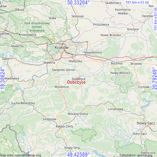
Dobczyce GPS coordinates[2]
49° 52' 51.924" North, 20° 5' 21.696" East
| Map corner | latitude | longitude |
|---|---|---|
| Upper-left | 50.33204°, | 19.38624° |
| Center: | 49.88109°, | 20.08936° |
| Lower-right: | 49.42589°, | 20.79249° |
| Map W x H: | 100.8×100.8 km | = 62.6×62.6mi |
| max Lat: | 54.83135° ⇑88.4% North |
| Dobczyce: | 49.88109° |
| min Lat: | ⇓11.6% South 49.21328° |
| min Long | Dobczyce | max Long |
| 14.20249° | 20.08936° | 24.03723° |
| W 59.7%⇐ | ⇒40.3% E |
Elevation
Elevation of Dobczyce is 243 m = 797 ft, and this is 51.6 m = 169 ft above average elevation for this country.
| Max E: |
974 m = 3196 ft | 25.8% |
| Dobczyce | 243 m 797 ft | |
| Avg. | 191.4 m = 628 ft | |
Min E: |
-3 m = -10 ft | 74.2% |
See also: Poland elevation on elevation.city.
Geographical zone
Dobczyce is located in North temperate zone (between Tropic of Cancer and the Arctic Circle). Distance of this North polar circle is 1854.9 km =1152.6 mi to North.| Distance of | km | miles | from Dobczyce |
|---|---|---|---|
| North Pole | 4460.8 | 2771.8 | to North |
| Arctic Circle | 1854.9 | 1152.6 | to North |
| Tropic Cancer | 2940.3 | 1827 | to South |
| Equator | 5546.3 | 3446.3 | to South |


Nearby cities:
15 places around Dobczyce: (largest is in red/bold)
• Biskupice
9.5 km =5.9 mi,  13°
13°
• Borzęta
8.2 km =5.1 mi,  255°
255°
• Brzezowa
3.6 km =2.2 mi,  221°
221°
• Brzączowice
3.8 km =2.4 mi, 259°
• Gdów
8.4 km =5.2 mi,  68°
68°
• Kornatka
3.4 km =2.1 mi,  185°
185°
• Osieczany
8.8 km =5.5 mi,  240°
240°
• Pawlikowice
8.4 km =5.2 mi,  342°
342°
• Raciechowice
5.6 km =3.5 mi,  136°
136°
• Siepraw
10.1 km =6.3 mi,  291°
291°
• Trzemeśnia
7.7 km =4.8 mi, 219°
• Trąbki
9.8 km =6.1 mi,  22°
22°
• Zasań
7.3 km =4.5 mi,  203°
203°
• Zręczyce
9.2 km =5.7 mi,  85°
85°
• Łęki
7.3 km =4.5 mi,  225°
225°
Sources, notices
• [Note1] Compared only with cities in Poland existing in our database
• [Src1] Map data: © OpenStreetMap contributors (CC-BY-SA)
• [Src2] Other city data from geonames.org with taken over terms of usage.
• [Src3] Geographical zone / Annual Mean Temperature by Robert A. Rohde @ Wikipedia
