Olszówka geodata
Olszówka (Lesser Poland) is a populated place; located in Poland in Europe/Warsaw (GMT+2) time zone. With population of 1,435 people, there are 1923 cities with bigger population in this country. Compared to other cities in Poland, 96.4% of cities are located further ↑North; 58.8% of cities are located further ←West and 97.3% of cities have lower elevation than Olszówka. Note1


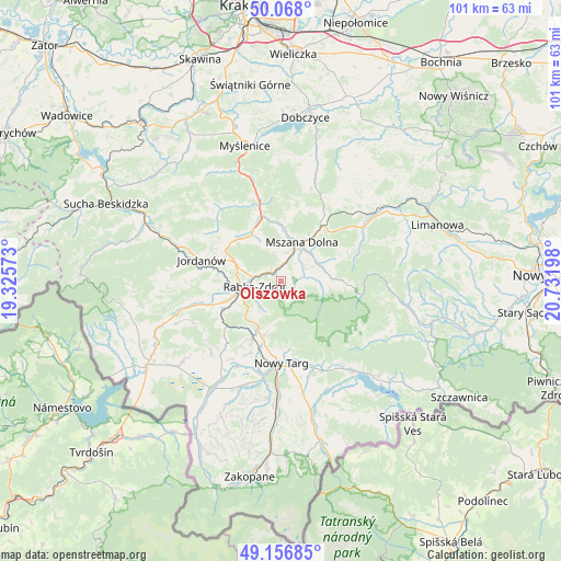
Olszówka GPS coordinates[2]
49° 36' 52.38" North, 20° 1' 43.86" East
| Map corner | latitude | longitude |
|---|---|---|
| Upper-left | 50.068°, | 19.32573° |
| Center: | 49.61455°, | 20.02885° |
| Lower-right: | 49.15685°, | 20.73198° |
| Map W x H: | 101.3×101.3 km | = 62.9×62.9mi |
| max Lat: | 54.83135° ⇑96.4% North |
| Olszówka: | 49.61455° |
| min Lat: | ⇓3.6% South 49.21328° |
| min Long | Olszówka | max Long |
| 14.20249° | 20.02885° | 24.03723° |
| W 58.8%⇐ | ⇒41.2% E |
Elevation
Elevation of Olszówka is 488 m = 1601 ft, and this is 296.6 m = 973 ft above average elevation for this country.
| Max E: |
974 m = 3196 ft | 2.7% |
| Olszówka | 488 m 1601 ft | |
| Avg. | 191.4 m = 628 ft | |
Min E: |
-3 m = -10 ft | 97.3% |
See also: Poland elevation on elevation.city.
Geographical zone
Olszówka is located in North temperate zone (between Tropic of Cancer and the Arctic Circle). Distance of this North polar circle is 1884.6 km =1171 mi to North.| Distance of | km | miles | from Olszówka |
|---|---|---|---|
| North Pole | 4490.4 | 2790.2 | to North |
| Arctic Circle | 1884.6 | 1171 | to North |
| Tropic Cancer | 2910.7 | 1808.6 | to South |
| Equator | 5516.6 | 3427.9 | to South |


Nearby cities:
15 places around Olszówka: (largest is in red/bold)
• Klikuszowa
11.1 km =6.9 mi,  196°
196°
• Lasek
12.3 km =7.6 mi, 196°
• Lubień
12.2 km =7.6 mi,  342°
342°
• Lubomierz
12.5 km =7.8 mi,  93°
93°
• Mszana Dolna
7.6 km =4.7 mi,  28°
28°
• Mszana Górna
7.2 km =4.5 mi,  43°
43°
• Naprawa
11.4 km =7.1 mi,  288°
288°
• Niedźwiedź
3.6 km =2.2 mi,  78°
78°
• Pyzówka
12.9 km =8 mi,  210°
210°
• Raba Wyżna
12 km =7.5 mi,  243°
243°
• Rabka-Zdrój
4.5 km =2.8 mi,  262°
262°
• Rokiciny
9 km =5.6 mi, 238°
• Sieniawa
11 km =6.8 mi,  220°
220°
• Wilczyce
13.7 km =8.5 mi,  64°
64°
• Wysoka
13 km =8.1 mi,  272°
272°
Sources, notices
• [Note1] Compared only with cities in Poland existing in our database
• [Src1] Map data: © OpenStreetMap contributors (CC-BY-SA)
• [Src2] Other city data from geonames.org with taken over terms of usage.
• [Src3] Geographical zone / Annual Mean Temperature by Robert A. Rohde @ Wikipedia
