Wilczyce geodata
Wilczyce (Lesser Poland) is a populated place; located in Poland in Europe/Warsaw (GMT+2) time zone. With population of 527 people, there are 3463 cities with bigger population in this country. Compared to other cities in Poland, 95.4% of cities are located further ↑North; 61.2% of cities are located further ←West and 99.5% of cities have lower elevation than Wilczyce. Note1


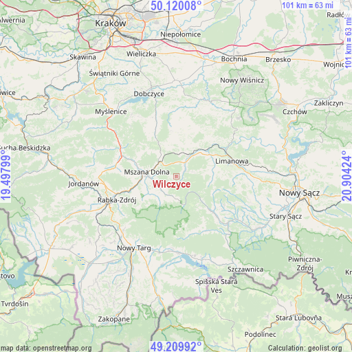
Wilczyce GPS coordinates[2]
49° 40' 1.668" North, 20° 12' 3.996" East
| Map corner | latitude | longitude |
|---|---|---|
| Upper-left | 50.12008°, | 19.49799° |
| Center: | 49.66713°, | 20.20111° |
| Lower-right: | 49.20992°, | 20.90424° |
| Map W x H: | 101.2×101.2 km | = 62.9×62.9mi |
| max Lat: | 54.83135° ⇑95.4% North |
| Wilczyce: | 49.66713° |
| min Lat: | ⇓4.6% South 49.21328° |
| min Long | Wilczyce | max Long |
| 14.20249° | 20.20111° | 24.03723° |
| W 61.2%⇐ | ⇒38.8% E |
Elevation
Elevation of Wilczyce is 670 m = 2198 ft, and this is 478.6 m = 1570 ft above average elevation for this country.
| Max E: |
974 m = 3196 ft | 0.5% |
| Wilczyce | 670 m 2198 ft | |
| Avg. | 191.4 m = 628 ft | |
Min E: |
-3 m = -10 ft | 99.5% |
See also: Poland elevation on elevation.city.
Geographical zone
Wilczyce is located in North temperate zone (between Tropic of Cancer and the Arctic Circle). Distance of this North polar circle is 1878.7 km =1167.4 mi to North.| Distance of | km | miles | from Wilczyce |
|---|---|---|---|
| North Pole | 4484.6 | 2786.6 | to North |
| Arctic Circle | 1878.7 | 1167.4 | to North |
| Tropic Cancer | 2916.5 | 1812.2 | to South |
| Equator | 5522.5 | 3431.5 | to South |


Nearby cities:
15 places around Wilczyce: (largest is in red/bold)
• Dobra
6.8 km =4.2 mi,  33°
33°
• Jodłownik
12.3 km =7.6 mi,  11°
11°
• Kamienica
14.5 km =9 mi,  134°
134°
• Kasina Wielka
8.4 km =5.2 mi,  325°
325°
• Lipnik
15.9 km =9.9 mi, 328°
• Lubomierz
6.5 km =4 mi,  179°
179°
• Mszana Dolna
8.8 km =5.5 mi,  275°
275°
• Mszana Górna
7.5 km =4.7 mi,  265°
265°
• Niedźwiedź
10.2 km =6.3 mi,  239°
239°
• Olszówka
13.7 km =8.5 mi, 244°
• Skrzydlna
9.7 km =6 mi,  353°
353°
• Słopnice
10.4 km =6.5 mi,  79°
79°
• Tymbark
11.3 km =7 mi,  52°
52°
• Wiśniowa
14.8 km =9.2 mi,  335°
335°
• Węglówka
11.2 km =7 mi,  311°
311°
Sources, notices
• [Note1] Compared only with cities in Poland existing in our database
• [Src1] Map data: © OpenStreetMap contributors (CC-BY-SA)
• [Src2] Other city data from geonames.org with taken over terms of usage.
• [Src3] Geographical zone / Annual Mean Temperature by Robert A. Rohde @ Wikipedia
