Niedźwiedź geodata
Niedźwiedź (Lesser Poland) is a populated place; located in Poland in Europe/Warsaw (GMT+2) time zone. With population of 1,400 people, there are 1959 cities with bigger population in this country. Compared to other cities in Poland, 96.3% of cities are located further ↑North; 59.5% of cities are located further ←West and 97.5% of cities have lower elevation than Niedźwiedź. Note1


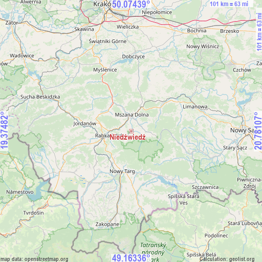
Niedźwiedź GPS coordinates[2]
49° 37' 15.6" North, 20° 4' 40.584" East
| Map corner | latitude | longitude |
|---|---|---|
| Upper-left | 50.07439°, | 19.37482° |
| Center: | 49.621°, | 20.07794° |
| Lower-right: | 49.16336°, | 20.78107° |
| Map W x H: | 101.3×101.3 km | = 62.9×62.9mi |
| max Lat: | 54.83135° ⇑96.3% North |
| Niedźwiedź: | 49.621° |
| min Lat: | ⇓3.7% South 49.21328° |
| min Long | Niedźwiedź | max Long |
| 14.20249° | 20.07794° | 24.03723° |
| W 59.5%⇐ | ⇒40.5% E |
Elevation
Elevation of Niedźwiedź is 495 m = 1624 ft, and this is 303.6 m = 996 ft above average elevation for this country.
| Max E: |
974 m = 3196 ft | 2.5% |
| Niedźwiedź | 495 m 1624 ft | |
| Avg. | 191.4 m = 628 ft | |
Min E: |
-3 m = -10 ft | 97.5% |
See also: Poland elevation on elevation.city.
Geographical zone
Niedźwiedź is located in North temperate zone (between Tropic of Cancer and the Arctic Circle). Distance of this North polar circle is 1883.8 km =1170.5 mi to North.| Distance of | km | miles | from Niedźwiedź |
|---|---|---|---|
| North Pole | 4489.7 | 2789.8 | to North |
| Arctic Circle | 1883.8 | 1170.5 | to North |
| Tropic Cancer | 2911.4 | 1809.1 | to South |
| Equator | 5517.3 | 3428.3 | to South |


Nearby cities:
15 places around Niedźwiedź: (largest is in red/bold)
• Kasina Wielka
12.8 km =8 mi,  18°
18°
• Klikuszowa
13.1 km =8.1 mi,  210°
210°
• Lasek
14.3 km =8.9 mi, 209°
• Lubień
13.1 km =8.1 mi,  326°
326°
• Lubomierz
9.1 km =5.7 mi,  98°
98°
• Mszana Dolna
5.9 km =3.7 mi,  1°
1°
• Mszana Górna
4.8 km =3 mi, 17°
• Naprawa
14.6 km =9.1 mi,  281°
281°
• Olszówka
3.6 km =2.2 mi,  258°
258°
• Rabka-Zdrój
8.1 km =5 mi, 260°
• Rokiciny
12.4 km =7.7 mi,  244°
244°
• Sieniawa
14 km =8.7 mi,  229°
229°
• Waksmund
15.4 km =9.6 mi,  180°
180°
• Wilczyce
10.2 km =6.3 mi,  59°
59°
• Węglówka
12.6 km =7.8 mi, 2°
Sources, notices
• [Note1] Compared only with cities in Poland existing in our database
• [Src1] Map data: © OpenStreetMap contributors (CC-BY-SA)
• [Src2] Other city data from geonames.org with taken over terms of usage.
• [Src3] Geographical zone / Annual Mean Temperature by Robert A. Rohde @ Wikipedia
