Lubień geodata
Lubień (Lesser Poland) is a populated place; located in Poland in Europe/Warsaw (GMT+2) time zone. With population of 3,200 people, there are 991 cities with bigger population in this country. Compared to other cities in Poland, 94% of cities are located further ↑North; 58% of cities are located further ←West and 91.2% of cities have lower elevation than Lubień. Note1


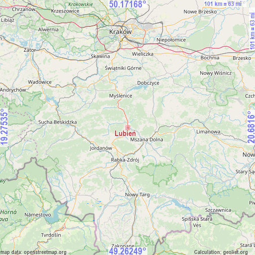
Lubień GPS coordinates[2]
49° 43' 9.156" North, 19° 58' 42.492" East
| Map corner | latitude | longitude |
|---|---|---|
| Upper-left | 50.17168°, | 19.27535° |
| Center: | 49.71921°, | 19.97847° |
| Lower-right: | 49.26249°, | 20.6816° |
| Map W x H: | 101.1×101.1 km | = 62.8×62.8mi |
| max Lat: | 54.83135° ⇑94% North |
| Lubień: | 49.71921° |
| min Lat: | ⇓6% South 49.21328° |
| min Long | Lubień | max Long |
| 14.20249° | 19.97847° | 24.03723° |
| W 58%⇐ | ⇒42% E |
Elevation
Elevation of Lubień is 347 m = 1138 ft, and this is 155.6 m = 510 ft above average elevation for this country.
| Max E: |
974 m = 3196 ft | 8.8% |
| Lubień | 347 m 1138 ft | |
| Avg. | 191.4 m = 628 ft | |
Min E: |
-3 m = -10 ft | 91.2% |
See also: Poland elevation on elevation.city.
Geographical zone
Lubień is located in North temperate zone (between Tropic of Cancer and the Arctic Circle). Distance of this North polar circle is 1872.9 km =1163.8 mi to North.| Distance of | km | miles | from Lubień |
|---|---|---|---|
| North Pole | 4478.8 | 2783 | to North |
| Arctic Circle | 1872.9 | 1163.8 | to North |
| Tropic Cancer | 2922.3 | 1815.8 | to South |
| Equator | 5528.3 | 3435.1 | to South |


Nearby cities:
15 places around Lubień: (largest is in red/bold)
• Kasina Wielka
11.4 km =7.1 mi,  84°
84°
• Krzczonów
4.8 km =3 mi,  295°
295°
• Lipnik
10.9 km =6.8 mi,  44°
44°
• Mszana Dolna
8.8 km =5.5 mi,  124°
124°
• Mszana Górna
10.7 km =6.6 mi,  126°
126°
• Naprawa
10.8 km =6.7 mi,  221°
221°
• Olszówka
12.2 km =7.6 mi,  162°
162°
• Pcim
3.6 km =2.2 mi,  351°
351°
• Poręba
9 km =5.6 mi,  17°
17°
• Rabka-Zdrój
12.3 km =7.6 mi,  184°
184°
• Skomielna Czarna
10.3 km =6.4 mi,  274°
274°
• Stróża
9.4 km =5.8 mi,  335°
335°
• Tokarnia
7.7 km =4.8 mi,  276°
276°
• Węglówka
7.9 km =4.9 mi, 77°
• Łętownia
8.1 km =5 mi,  252°
252°
Sources, notices
• [Note1] Compared only with cities in Poland existing in our database
• [Src1] Map data: © OpenStreetMap contributors (CC-BY-SA)
• [Src2] Other city data from geonames.org with taken over terms of usage.
• [Src3] Geographical zone / Annual Mean Temperature by Robert A. Rohde @ Wikipedia
