Kamionka geodata
Kamionka (Lublin) is a seat of a third-order administrative division; located in Poland in Europe/Warsaw (GMT+2) time zone. With population of 1,800 people, there are 1605 cities with bigger population in this country. Compared to other cities in Poland, 55.8% of cities are located further ↓South; 91.2% of cities are located further ←West and 58.7% of cities have higher elevation than Kamionka. Note1


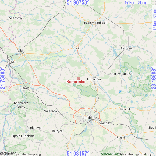
Kamionka GPS coordinates[2]
51° 28' 17.94" North, 22° 27' 45.9" East
| Map corner | latitude | longitude |
|---|---|---|
| Upper-left | 51.90753°, | 21.75963° |
| Center: | 51.47165°, | 22.46275° |
| Lower-right: | 51.03157°, | 23.16588° |
| Map W x H: | 97.4×97.4 km | = 60.5×60.5mi |
| max Lat: | 54.83135° ⇑44.2% North |
| Kamionka: | 51.47165° |
| min Lat: | ⇓55.8% South 49.21328° |
| min Long | Kamionka | max Long |
| 14.20249° | 22.46275° | 24.03723° |
| W 91.2%⇐ | ⇒8.8% E |
Elevation
Elevation of Kamionka is 149 m = 489 ft, and this is 42.4 m = 139 ft below average elevation for this country.
| Max E: |
974 m = 3196 ft | 58.7% |
| Avg. | 191.4 m = 628 ft | |
| Kamionka | 149 m = 489 ft | |
Min E: |
-3 m = -10 ft | 41.3% |
See also: Poland elevation on elevation.city.
Geographical zone
Kamionka is located in North temperate zone (between Tropic of Cancer and the Arctic Circle). Distance of this North polar circle is 1678.1 km =1042.7 mi to North.| Distance of | km | miles | from Kamionka |
|---|---|---|---|
| North Pole | 4284 | 2662 | to North |
| Arctic Circle | 1678.1 | 1042.7 | to North |
| Tropic Cancer | 3117.2 | 1936.9 | to South |
| Equator | 5723.1 | 3556.2 | to South |


Nearby cities:
15 places around Kamionka: (largest is in red/bold)
• Abramów
10.4 km =6.5 mi,  260°
260°
• Firlej
10.2 km =6.3 mi,  18°
18°
• Garbów
15.9 km =9.9 mi,  215°
215°
• Jastków
18.7 km =11.6 mi,  185°
185°
• Kozłówka
3.4 km =2.1 mi,  136°
136°
• Lubartów
10.2 km =6.3 mi,  97°
97°
• Markuszów
17.8 km =11.1 mi,  232°
232°
• Michów
11.9 km =7.4 mi,  300°
300°
• Niedźwiada
17.8 km =11.1 mi,  63°
63°
• Niemce
17.3 km =10.7 mi,  134°
134°
• Ostrówek
16 km =9.9 mi,  40°
40°
• Pałecznica
14.6 km =9.1 mi,  84°
84°
• Przybysławice
17 km =10.6 mi, 227°
• Serniki
14.1 km =8.8 mi,  105°
105°
• Wola Sernicka
15.5 km =9.6 mi, 99°
Sources, notices
• [Note1] Compared only with cities in Poland existing in our database
• [Src1] Map data: © OpenStreetMap contributors (CC-BY-SA)
• [Src2] Other city data from geonames.org with taken over terms of usage.
• [Src3] Geographical zone / Annual Mean Temperature by Robert A. Rohde @ Wikipedia
