Husów geodata
Husów (Subcarpathian) is a populated place; located in Poland in Europe/Warsaw (GMT+2) time zone. With population of 2,000 people, there are 1469 cities with bigger population in this country. Compared to other cities in Poland, 83.9% of cities are located further ↑North; 88.6% of cities are located further ←West and 91.1% of cities have lower elevation than Husów. Note1


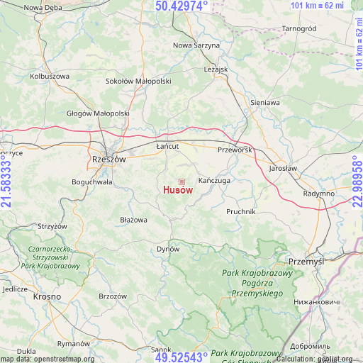
Husów GPS coordinates[2]
49° 58' 46.956" North, 22° 17' 11.22" East
| Map corner | latitude | longitude |
|---|---|---|
| Upper-left | 50.42974°, | 21.58333° |
| Center: | 49.97971°, | 22.28645° |
| Lower-right: | 49.52543°, | 22.98958° |
| Map W x H: | 100.5×100.5 km | = 62.4×62.4mi |
| max Lat: | 54.83135° ⇑83.9% North |
| Husów: | 49.97971° |
| min Lat: | ⇓16.1% South 49.21328° |
| min Long | Husów | max Long |
| 14.20249° | 22.28645° | 24.03723° |
| W 88.6%⇐ | ⇒11.4% E |
Elevation
Elevation of Husów is 346 m = 1135 ft, and this is 154.6 m = 507 ft above average elevation for this country.
| Max E: |
974 m = 3196 ft | 8.9% |
| Husów | 346 m 1135 ft | |
| Avg. | 191.4 m = 628 ft | |
Min E: |
-3 m = -10 ft | 91.1% |
See also: Poland elevation on elevation.city.
Geographical zone
Husów is located in North temperate zone (between Tropic of Cancer and the Arctic Circle). Distance of this North polar circle is 1844 km =1145.8 mi to North.| Distance of | km | miles | from Husów |
|---|---|---|---|
| North Pole | 4449.8 | 2765 | to North |
| Arctic Circle | 1844 | 1145.8 | to North |
| Tropic Cancer | 2951.3 | 1833.9 | to South |
| Equator | 5557.2 | 3453.1 | to South |


Nearby cities:
15 places around Husów: (largest is in red/bold)
• Albigowa
5.9 km =3.7 mi,  310°
310°
• Chmielnik
10.1 km =6.3 mi,  266°
266°
• Gać
7.4 km =4.6 mi,  44°
44°
• Hadle Szklarskie
7.6 km =4.7 mi,  172°
172°
• Handzlówka
4.8 km =3 mi,  290°
290°
• Hyżne
10.2 km =6.3 mi,  227°
227°
• Jawornik Polski
9.9 km =6.2 mi,  179°
179°
• Kańczuga
9 km =5.6 mi,  87°
87°
• Manasterz
6.5 km =4 mi,  139°
139°
• Markowa
6.1 km =3.8 mi,  31°
31°
• Siedleczka
7 km =4.3 mi,  107°
107°
• Sietesz
4.4 km =2.7 mi,  80°
80°
• Sonina
9.1 km =5.7 mi,  350°
350°
• Wysoka
7.5 km =4.7 mi, 345°
• Łopuszka Wielka
9.1 km =5.7 mi,  123°
123°
Sources, notices
• [Note1] Compared only with cities in Poland existing in our database
• [Src1] Map data: © OpenStreetMap contributors (CC-BY-SA)
• [Src2] Other city data from geonames.org with taken over terms of usage.
• [Src3] Geographical zone / Annual Mean Temperature by Robert A. Rohde @ Wikipedia
