Markowa geodata
Markowa (Subcarpathian) is a seat of a third-order administrative division; located in Poland in Europe/Warsaw (GMT+2) time zone. With population of 4,100 people, there are 794 cities with bigger population in this country. Compared to other cities in Poland, 81.1% of cities are located further ↑North; 89.5% of cities are located further ←West and 64.8% of cities have lower elevation than Markowa. Note1


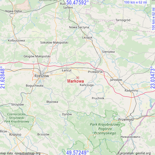
Markowa GPS coordinates[2]
50° 1' 34.788" North, 22° 19' 53.76" East
| Map corner | latitude | longitude |
|---|---|---|
| Upper-left | 50.47592°, | 21.62848° |
| Center: | 50.02633°, | 22.3316° |
| Lower-right: | 49.57249°, | 23.03473° |
| Map W x H: | 100.5×100.4 km | = 62.4×62.4mi |
| max Lat: | 54.83135° ⇑81.1% North |
| Markowa: | 50.02633° |
| min Lat: | ⇓18.9% South 49.21328° |
| min Long | Markowa | max Long |
| 14.20249° | 22.3316° | 24.03723° |
| W 89.5%⇐ | ⇒10.5% E |
Elevation
Elevation of Markowa is 214 m = 702 ft, and this is 22.6 m = 74 ft above average elevation for this country.
| Max E: |
974 m = 3196 ft | 35.2% |
| Markowa | 214 m 702 ft | |
| Avg. | 191.4 m = 628 ft | |
Min E: |
-3 m = -10 ft | 64.8% |
See also: Poland elevation on elevation.city.
Geographical zone
Markowa is located in North temperate zone (between Tropic of Cancer and the Arctic Circle). Distance of this North polar circle is 1838.8 km =1142.6 mi to North.| Distance of | km | miles | from Markowa |
|---|---|---|---|
| North Pole | 4444.7 | 2761.8 | to North |
| Arctic Circle | 1838.8 | 1142.6 | to North |
| Tropic Cancer | 2956.5 | 1837.1 | to South |
| Equator | 5562.4 | 3456.3 | to South |


Nearby cities:
15 places around Markowa: (largest is in red/bold)
• Albigowa
7.8 km =4.8 mi,  260°
260°
• Białobrzegi
8.5 km =5.3 mi,  353°
353°
• Dębów
7.7 km =4.8 mi,  74°
74°
• Gać
2 km =1.2 mi,  88°
88°
• Głuchów
7.5 km =4.7 mi,  325°
325°
• Handzlówka
8.5 km =5.3 mi,  245°
245°
• Husów
6.1 km =3.8 mi,  211°
211°
• Kańczuga
7.4 km =4.6 mi,  129°
129°
• Kosina
5.1 km =3.2 mi,  357°
357°
• Nowosielce
6.6 km =4.1 mi,  58°
58°
• Rogóźno
6.1 km =3.8 mi,  30°
30°
• Siedleczka
8.1 km =5 mi,  154°
154°
• Sietesz
4.6 km =2.9 mi,  166°
166°
• Sonina
6.1 km =3.8 mi,  309°
309°
• Wysoka
5.5 km =3.4 mi,  291°
291°
Sources, notices
• [Note1] Compared only with cities in Poland existing in our database
• [Src1] Map data: © OpenStreetMap contributors (CC-BY-SA)
• [Src2] Other city data from geonames.org with taken over terms of usage.
• [Src3] Geographical zone / Annual Mean Temperature by Robert A. Rohde @ Wikipedia
